username
X
password
register
for free!
help
 

Boulders Loop Trail - PATS, AZ

Guide 53 Triplogs  0 Topics
  3.5 of 5  
Fav
Wish
4
details
drive
no permit
forecast
route  
stats
photos
triplogs
topics
location
223 53 0
Statistics
tap row or icons for details
Difficulty 1.5 of 5
Route Finding 1 of 5
Distance Lasso-Loop 2.7 miles
Trailhead Elevation 4,561 feet
Elevation Gain 200 feet
Accumulated Gain 300 feet
Avg Time Round Trip 2 hours
Kokopelli Seeds 4.2
 Interest Seasonal Creek
 Backpack Possible & Connecting
feature photo
Photos Viewed All MineFollowing
Will recalculate on button tap!
21  2024-03-22
Stewart Ridge/Pocket - Gibson Peak Sampler
The_Eagle
10  2024-03-22
Gibson Peak via Stewart Ridge
LindaAnn
9  2024-03-22
Stewart Ridge/Pocket - Gibson Peak Sampler
trekkin_gecko
7  2024-03-22
Stewart Ridge/Pocket - Gibson Peak Sampler
johnlp
10  2023-11-06
Stewart Pocket Grand Circle
The_Eagle
11  2023-11-06
Stewart Pocket Grand Circle
Tortoise_Hiker
5  2023-02-20
Boulders - Monument Peak Figure 8
pseudalpine
11  2022-10-04
Cypress - Boulders - Monument Loops
The_Eagle
Page 1,  2,  3,  4
Author
author avatar Guides 170
Routes 148
Photos 5,914
Trips 2,097 map ( 11,156 miles )
Age 48 Male Gender
Location Tucson, AZ
Associated Areas
list map done
Payson Region
Historical Weather
Trailhead Forecast
Radar Map
Expand Map
Preferred Apr, Oct, Mar, Nov
Seasons   ALL
Sun  6:00am - 6:47pm
Official Route & 1 Rt
 
14 Alternative


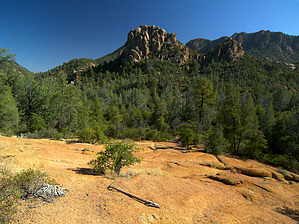
The big attraction in Stewart's Pocket
by PrestonSands

Note
FR #435 is currently blocked about 1/4 mi from the "Boulders Trail" sign. This will add to the posted distance.


This loop hike is made up of the Boulders North Trail and the Boulders South Trail, collectively known as the Boulders Loop Trail. Now a part of the Payson Area Trails System or P.A.T.S., this scenic loop hike takes one through the eroded granite formations of Payson's Granite Dells. This description is of a clockwise hike. Pay close attention to the P.A.T.S. trail signs to avoid taking a wrong turn onto one of the area's numerous ATV paths.
remove free decal offer
From the trailhead sign, the Boulders Trail drops down and then crosses the eroded channel of Stewart Creek. Once across, the Boulders Trail immediately arrives at a signed junction, where it splits into the Boulders North and Boulders South Trails. Take a left onto the Boulders South Trail. This trail soon reaches an open, sandy flat with views of the area's boulder formations. To the south, Gibson Peak's rugged facade towers high above. The trail departs the flat to ramble southwest along the route of a dry creek bed while heading toward a prominent needle.

Approaching the one-mile point, the Boulders South Trail turns west and becomes more of a cross country route, traveling along sandy washes and bedrock in places. Watch for trail emblems nailed to trees to stay on route.

The trail travels through a wide pass and turns north at 1.5 miles, before reaching the wooded course of Stewart Creek at 1.7 miles. The Boulders South Trail meets the Cypress Trail and the Boulders North Trail at a signed junction in the creek bottom. Turn right (east) onto the Boulders North Trail.

The Boulders North Trail follows the gently descending wash of Stewart Creek and weaves in and out of stands of Rocky Mountain juniper and Arizona cypress. A few willows, raspberries, and other moisture-loving plants cluster around the occasional moist patch in the creek bed.

Stewart Creek pinches into a small box at 2.2 miles, tumbling through granite bedrock, while the trail bypasses this section by climbing over a small ridge. As the trail descends to the creek again, the terrain opens up to reveal a fine view to the east, down Stewart Canyon.

Back along the creek, the Boulders North Trail passes through a nice stand of cypress, skirts the north side of a large boulder outcropping, and arrives back at the signed junction with the Boulders South Trail at 2.6 miles. Take the Boulders Trail back across Stewart Creek's gravel chasm to return to the trailhead at 2.7 miles.

2008-11-05 PrestonSands
  • PATS map
    area related


Check out the Official Route and Triplogs.
Leave No Trace and +Add a Triplog after your hike to support this local community.
WARNING! Hiking and outdoor related sports can be dangerous. Be responsible and prepare for the trip. Study the area you are entering and plan accordingly. Dress for the current and unexpected weather changes. Take plenty of water. Never go alone. Make an itinerary with your plan(s), route(s), destination(s) and expected return time. Give your itinerary to trusted family and/or friends.

 Permit $$
None


 Directions
or
 Road
FR / Dirt Road / Gravel - Car Okay

To hike
From the junction of highways 87 and 260 in Payson, head east on Highway 260 for 0.3 miles to the Granite Dells Road stoplight (next to Safeway). Turn right onto Granite Dells Road (Forest Road #435) and follow it for 3.85 miles to the large brown "Boulders Trail" sign next to the road. A fiberglass signpost for "The Boulders" marks the start of the trail (see hike description).

2010-11-08 casfranklin writes: FR #435 is currently blocked about 1/4 mi from the "Boulders Trail" sign. This may be due to a large wash-out near the sign... About 50 feet before the sign is a large cairn marking the easiest descent to the dry Stewart's Creek bed. Crossing the creek bed diagonally left is a large boulder marking the incline to the trail start.
page created by PrestonSands on Nov 04 2008 9:05 pm
 90+° 8am - 6pm kills
helpcorrectionissue

end of page marker