Route Editor

| Guide | ♦ | 3 Triplogs | 1 Topic |
details | drive | permit | forecast | map |
stats |
photos | triplogs | topic | location |
| 25 | 3 | 1 |
Canyons are inherently risky. Flash floods occur without notice on sunny days. Technical skills & surrounding topography knowledge required yet does not eliminate risk.
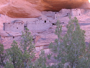
A Walk Back in Time by azdesertfather  There aren't too many hikes where you can go and feel like you're walking on sacred, pristine earth. On my trip to see Three Turkey Ruins, I have to admit I felt just that. At the invitation of a Navajo family, I joined a father and his son into the ruins to see them. There aren't too many hikes where you can go and feel like you're walking on sacred, pristine earth. On my trip to see Three Turkey Ruins, I have to admit I felt just that. At the invitation of a Navajo family, I joined a father and his son into the ruins to see them.The area, inhabited centuries ago by the many Anasazi, are thankfully due to their location pretty pristine. The original structures are still standing well in the main area and parts of the ones above and to the right of them inside the canyon. Inside the perpetually dark kiva, the artwork is stunning. I didn't get to see it firsthand, but my friend had and told me about it. I was able to see the three turkeys pained atop one of the buildings there in brown and white, which gives the ruins their name.
Even the drive in was fascinating. On that final stretch, we passed a very old, abandoned hogan and corral, as well as a sweat lodge on the side of this little road. Hike: We hiked down into the canyon (also known as Tse Deeshzhaai Wash), and once we were in, all I can say is, WOW. It felt like I had just stepped centuries back in time, walking on earth that is very seldom trod. There are a few who get out there, and when we were out there, we ran into a couple of Navajo on horseback; (thankfully) not very many. I had such a deep sense of appreciation for the canyon and ruins' pristine condition. There was a little bit of graffiti in there, but thankfully it was very minimal. I saw two small patches of it on the walls, dated as far back as 1969. But considering other areas I've seen around the state, it's not that bad. Along the hike through the canyon (which does have seasonal water running through it), we found a small set of ruins up on a ledge to the right that was easy to reach, though there wasn't much to them. As you're in the canyon, the views of the walls of the canyons are breathtaking. I felt like a country boy in New York City, with my neck stretched, looking up all of the time! Sheer vertical walls, several hundred feet straight up, with echoes in there that could be heard for hundreds of yards. When we finally arrived at the Three Turkey Ruins, I gasped. It was one of those feelings like when I saw the Grand Canyon for the first time. Situated halfway up the rock wall above the canyon floor, this site served as a very strategic position, no doubt. It would have been impossible to reach by their enemies, and the echoes in the canyon would have warned them of intruders well before they got there. Anyone coming in there unwanted by the Anasazi, you can tell, wouldn't have even had a fighting chance! I debated whether or not to even make this post. When someone like me sees something this pristine, this untouched by modern man, one feels the urge to keep it a secret and not let others know about it. In the end, I decided that something this beautiful I can't just keep to myself. For those interested, I do know that Totsonii Ranch offers guided tours into the area. It is located nearby (on the edge of the National Monument land) and run by a Navajo family. If you are interested in going in, please contact them rather than venturing out there on Navajo land on your own (Google "Totsonii Ranch" for further information.) They'll even take you in on horseback...check their website for further details. I didn't make the directions to the trailhead too user-friendly because I selfishly hope that the casual hiker that isn't as respectful of areas like this won't go in without a guide. Be forewarned...those deciding to venture out on their own down these Navajo roads risk easily getting lost. What's more, many of these roads lead onto homesites, and Navajo families don't take too kindly to outsiders driving/traipsing around on their personal property! Check out the Triplogs. Leave No Trace and +Add a Triplog after your canyon trip to support this local community. | ||||||||||||||||||||||||||||||||||||||||||||||||||||||||||||||||||||||||||||||||||||||||||||||||