Route Editor

| Guide | ♦ | 22 Triplogs | 0 Topics |
details | drive | no permit | forecast | 🔥 route |
stats |
photos | triplogs | topics | location |
| 139 | 22 | 0 |
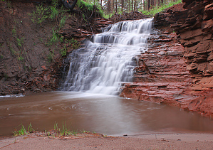
Tiny Creek, Big Falls by RickVincent  Warning WarningOff Trail hiking. Not a designated trail. Requires route finding skills. Never enter an area posted closed or no trespassing. If you have questions not answered here STAY AWAY!
The Wallow Fire burnt the area. Deadfall and blackened trees have really killed the beauty of this spot. A large Ponderosa has fallen directly across the waterfall. Overview Auger Canyon is located in the White Mountains just south of Nutrioso. The Wallow Fire of 2011 left its devastating mark on upper Auger, but lower Auger was mostly spared. Although many of the tall Ponderosa pines are charred by wildfire, a large majority of the trees in this lower section survived the devastating blaze. Unfortunately, fire damage to the upper Auger Canyon is extreme. You won't find a single mature tree that survived the blaze in upper Auger. For this reason, this description only covers the lower half of the canyon. Approach From your turn onto Auger Canyon Road you will drive through two meadows before an obvious ascent into the treeline. Within a few hundred yards there will be a dirt pullout on your right just before an open-gated entry into National Forest Land. For safety reasons, this road was closed for about a year after the Wallow Fire but has since reopened. Hike From the dirt pull-out, start your way into the woods directly east. There will be private property on your left. Follow the property fence line until you reach the creek. The creek is not much to look at...sometimes only one to two feet wide and slow-moving. Take a look at the banks of the creek and you will see evidence of how this creek can look in flash flood conditions. The creek takes on more personality during rainy seasons. From the creek, follow a game trail that runs along the west bank. This game trail will soon crossover to the east at the beginning of a small meadow-like opening in the trees. Jump the creek and make your way up the east bank. You will pick up an old closed jeep road from here. At about 1 mile from where you started, start making your way towards the creek. You will hear the sound of running water. The 15-foot cascading falls are not far away. Depending on the flow, these falls range from mildly interesting to an impressive display of water bouncing its way down the sandstone wall. On my recent trip, the falls were at least 9 feet wide at the base. After you've enjoyed your time at the falls, I recommend going back to the jeep road and continuing into a large meadow. You will come across a stand of aspen on your right (east), half of which appears healthy with green leaves, and the other half appears which appears to be fire damaged. As you near the end of this meadow, leave the jeep road and hike through the tall grass towards the creek. Just as you begin to enter a severely fire-damaged section of the forest you will come to another jeep road on the west side of the creek that leads up the hill and back to the main road. You will have hiked about 2 miles at this point and you will be at the edge of the total burn area. Follow the main road back to your vehicle or retrace your steps back down the same route. Check out the Official Route and Triplogs. Leave No Trace and +Add a Triplog after your hike to support this local community. | |||||||||||||||||||||||||||||||||||||||||||||||||||||||||||||||||||||||||||||||||||||