Route Editor

| Guide | ♦ | 8 Triplogs | 0 Topics |
details | drive | permit | forecast | map |
stats |
photos | triplogs | topics | location |
| 26 | 8 | 0 |
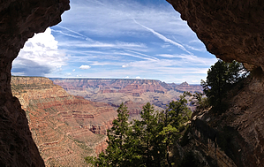
Before the Gram - God Created HAZ by HAZ_Hikebot   This short off-trail hike leads you along the rim near the old alignment of the East Rim Road to a sinkhole on top of the rim that drops down and leads to a large opening in the wall of the canyon below the rim. Just a few yards away below the rim is an overhang that features some very nice pictographs. This short off-trail hike leads you along the rim near the old alignment of the East Rim Road to a sinkhole on top of the rim that drops down and leads to a large opening in the wall of the canyon below the rim. Just a few yards away below the rim is an overhang that features some very nice pictographs.Check out the Triplogs. Leave No Trace and +Add a Triplog after your hike to support this local community. | |||||||||||||||||||||||||||||||||||||||||||||||||||||||||||||||||||||