 Route Editor

| Guide | ♦ | 1 Triplog | 0 Topics |
details | drive | permit | forecast | 🔥 route |
stats |
photos | triplog | topics | location |
| 48 | 1 | 0 |
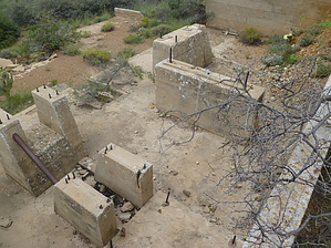
Shafted by kingsnake   Overview OverviewSince I've been up in the Wilhoit area regularly since June, beterarcher suggested I check out some of the mines northwest of town. So, I put this loop together which hits most of the points of interest I found while surveying the topo and sat views of the area. (Some of the topo POIs no longer exist.) Warning Lots of ATVs and dirt bikes in the area. Hunters as well, if in season. Since most of the hike is on jeep trails, keep your ears open behind you.
The hike starts at the small metal tank that marks the boundary between Wilhoit and the Prescott NF. Walk down the eroded hard pack, not the better-maintained city dirt road. 0.6 mi.: Shooting range on the edge of Copper Basin Wash. The trail splits; stay right. There are lots of ATV trails in the area; if you stay on the most well-worn one, you will be heading in the correct direction, as the trail turns from sand back to hardpack. 1.25 mi.: As you climb out of the wash, you will pass through an ungated fence. Stay left of the obvious hill in front of you, Hill 5225. 2.0 mi.: You are approaching the "blockhouse". There's a bunch of mine stuff in a 200-yard radius of the building. What order you do them in is up to you, but following the official route, turn left down the wash just before the building. A couple of hundred yards down the wash, you will see a thumb-like rock; turn right, towards it, out of the wash. 2.25 mi.: USMM 3770. Cut across the wash to the west of the USMM, to the jeep trail. 2.6 mi.: A building that the topo says is there, but which I could not find. Head north on the jeep trail. 2.9 mi.: Two vertical mine shafts, and some other mine stuff. (The topo refers to this as the "Mint Shaft".) The shafts have slippery sloped sides. The larger of the two is the home of a pair of owls Have your camera ready when you approach, and approach carefully: You should get better photos than I did. 3.1 mi.: Back to the blockhouse mining complex. Lots of stuff to see there. 3.4 mi.: Continue north up the jeep trail towards the blue tank. At this point, you will pass through another ungated fence. 3.7 mi.: The blue tank has a pipe running into from a vertical shaft that is a few yards upslope. The adjacent slope looks like some exploratory digging has occurred. From there proceed east up Hill 5635. There's a fair bit of brush, but also enough open areas and animal trails that getting up should be easy. 4.0 mi.: Hill 5635 is marked by an orange metal pole, set in a triangular metal plate, which is, in turn, mounted to a concrete block. There is no mark of any kind, that I could find, in the area. Great views north to Copper Basin, down Copper Basin Wash to Wilhoit, then across Peeples Valley to Skull Valley. It would not be a bad place to camp, especially since you are well away from any motor vehicle access. After resting, proceed southeast down a spur towards Copper Basin Wash. You will frequently zig-zag to avoid brush, but it can be easily avoided ... until you are about 100 yards from the bottom. Then it gets thick and you will need to beat your way through it. 5.0 mi.: Auto wreckage at the foot of Hill 5635. To get on the jeep trail to the next mine, first pass through a gated fence. The mine is about 200 yards north. After that head back down the jeep trail, then into Copper Basin Wash. The wash is narrow, sometimes rocky, sometimes sandy, but not too deep, and very easy to travel. 6.1 mi.: The wash crosses a jeep trail. If you go east, it will eventually turn to a foot trail to the top of Hill 6276 / USMM 3275. There is a corral at the intersection; despite the topo, there is no building. Pass through an ungated fence into the corral, then another ungated fence out of it, back into Copper Basin Wash. 6.7 mi.: The wash starts opening up, getting sandier, with more obvious vehicle tracks. 7.2 mi.: Close the loop at the shooting range. 7.8 mi.: Miller time! Check out the Official Route and Triplog. Leave No Trace and +Add a Triplog after your hike to support this local community. One-Way Notice This hike is listed as One-Way. When hiking several trails on a single "hike", log it with a generic name that describes the hike. Then link the trails traveled, check out the example. | |||||||||||||||||||||||||||||||||||||||||||||||||||||||||||||||||||||||||||||||||||||||||||


