Route Editor

| Guide | ♦ | 68 Triplogs | 0 Topics |
details | drive | no permit | forecast | route |
stats |
photos | triplogs | topics | location |
| 17 | 68 | 0 |
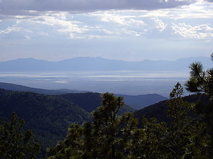
Hike Bike or Run... by imike Osha Trail (T10) formally includes the 1.8 mile loop designated as Forest Trail 10 plus the .2 mile spur trail section leading down to Hiway 82, where the Trailhead is established. This easy to reach trailhead along the main road leading into Cloudcroft, NM attracts many passerbys... and makes this one of the busier trails in the area. In addition to this basic loop, there are numerous options to expand the mileage along adjacent and connecting trails: T568... gives a .2 mile connection over to Pines Campground T568A...connects the Village of Cloudcroft with Pines Campground (and laps over the Osha Trail) T5688...provides a .5 mile connection over to Forest Road 206C (Bailey Canyon access)
These connecting trails are especially nice if you are on your mountain bike... the various and numerous options for explorations provide a diverse outing with only medium level difficulty. Note: If the Loop is begun at the Trailhead, be aware that the spur connecting up to the loop covers a 30% grade, using numberous log step ups. For a conditioned hiker this is just a fun traverse... but anyone out of shape or with knee problems might want to avoid this hit. Early mornings provide excellent chances to encounter the numerous elk, deer and the occasional bear... along with a nice grouping of wild turkeys that frequent the meadow midway through the loop. This hike is an excellent route to enjoy a lively trail run. Done clockwise you will encounter three upgrades, each a bit more difficult than the other. The downhill footing is challenging for running but very doable. There is a rewarding view of the White Sands playa, 4500' below... and a nice perspective view of the Village of Cloudcroft. Seasonally, wildflowers abound. Be prepared for people midday, but for the most part you can get a sense of being off and away; like most of the trails in this mountain range... the usage is minimal. Check out the Official Route and Triplogs. Leave No Trace and +Add a Triplog after your hike to support this local community. | ||||||||||||||||||||||||||||||||||||||||||||||||||||||||||||||||||||||||||||||||||||||||||||