Route Editor

| Guide | ♦ | 3 Triplogs | 0 Topics |
details | drive | no permit | forecast | route |
stats |
photos | triplogs | topics | location |
| 254 | 3 | 0 |
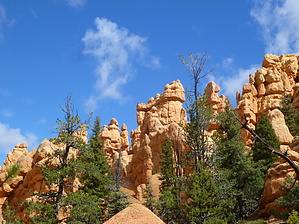
Hoodoo you love? by kingsnake Warning: There are many sections of this trail that are slippery, narrow and off-camber (the trail slopes sideways downslope). It can be hiked without poles, but they would be very useful for balance and braking.
0.60 mi.: The Golden Wall Trail splits right. Turn left onto Castle Bridge Trail. The first of two steep climbs begins. 1.05 mi.: High point of Castle Bridge Trail is a narrow, slippery spur. Edge out on it to get good views of the Sevier River valley, and points west. Descend into a small canyon. 1.20 mi.: Rejoin Golden Wall Trail, then begin the second climb up the phone/power line saddle. 1.73 mi.: Pass under the phone/power line, then begin a slight descent on the nicest section of trail surface on the north side of a wash. If you like wash walking, you could easily continue down the wash, which exits at the Cassidy TH, .75 miles east of the visitors' center. Otherwise, turn west up the trail to a narrow, exposed saddle. 2.52 mi.: The highpoint of the hike is on that narrow, exposed saddle. Beware high winds: I almost got knocked off my feet. Descend southeast down an even narrower spur, which actually has railroad tie steps for several hundred yards. 2.74 mi.: The trail begins meandering in and out of draws as it follows the countour line for the next half mile. This is probably the slipperiest, most off-camber section of trail. 3.17 mi.: Just before you reach the first bench (of four on Buckhorn Trail), a short side trail proceeds up a nearby knoll. The visitors center staff told me it is the narrowest, slipperiest trail in this area. The side trail will add a half mile and 200 AEG, round trip, to your hike. Take a sit down break at the first bench, and enjoy the views while you have a bite to eat. Afterwards, begin descending the switchbacks to the 30+ space Red Canyon Campground. 3.91 mi.: Take the road to the far west end of the campground. It's not exiciting, but at least you can enjoy the smell of some good cookouts. (And if you are bold enough, weasel a brat.) 4.28 mi.: Begin following the Utah 12 wash back to where you began. 4.81 mi.: Polygamy Porter time! (So good, you can't have just one.) Check out the Official Route and Triplogs. Leave No Trace and +Add a Triplog after your hike to support this local community. | |||||||||||||||||||||||||||||||||||||||||||||||||||||||||||||||||||||||||||||||||||||