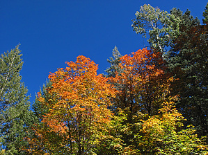
On the Mogollon Rim off FR321 with a short drive up FR218C at the "uppermost end" of McClintock Draw, during prime Autumn season (~early to mid-October), a colorful, beginner off-trail hike to view a large pocket of Big Tooth Maple with some Arizona Quaking Aspen.
If so desired, this "out and back" hiking area can be extended for a number of additional miles further down and back up Bill McClintock Draw.
WARNING! Hiking and outdoor related sports can be dangerous. Be responsible and prepare for the trip. Study the area you are entering and plan accordingly. Dress for the current and unexpected weather changes. Take plenty of water. Never go alone. Make an itinerary with your plan(s), route(s), destination(s) and expected return time. Give your itinerary to trusted family and/or friends.
Permit $$
None
Directions
Road
High Clearance possible when dry
To hike From Phoenix:
HWY 87 to north of Strawberry to Mogollon Rim top to
Rim Road FR300 (at MP281.1) to FR321 to FR218C
--- or ---
HWY 87 to north of Strawberry to Mogollon Rim top to Hwy 87 north of Clints Well to FR95 to FR96 (at East Clear Creek bridge crossing) to FR321 to FR218C "unmarked" park and TH Start.
Download and follow the posted GPS "Driving Route"(with included waypoint for Parking/TH Start).
page created by Grasshopper on Oct 05 2013 11:25 am
 Route Editor

 On the Mogollon Rim off FR321 with a short drive up FR218C at the "uppermost end" of McClintock Draw, during prime Autumn season (~early to mid-October), a colorful, beginner off-trail hike to view a large pocket of Big Tooth Maple with some Arizona Quaking Aspen.