Route Editor

| Guide | ♦ | 1 Triplog | 0 Topics |
details | drive | permit | forecast | route |
stats |
photos | triplog | topics | location |
| 9 | 1 | 0 |
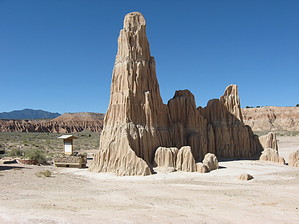
Gorge on the Scenery by autumnstars  Cathedral Gorge State Park was designated as one of four original state parks in 1935 to preserve the badlands-style geology. Silt, clay, and volcanic ash are being continuously eroded by rain to form towers, spires, narrow slots, and cliffs. The trail makes an easy loop around the bottom of a valley surrounded by these formations. Start from the trailhead and simply follow the trail. Once you loop through the valley and start to head back toward the CCC water tower, a signed spur trail will take you to Miller Point. This spur takes you up a few sets of metal stairs to an overlook of the valley. Once up top, walk down the road a ways to the short trail (~0.5 mi) for Eagle View - it is by far the better view. From here, back-track to resume the loop and head toward the tower.
Behind the day use area, there are a number of slot canyons in the clay that you can crawl and/or squeeze through. Some are named and signed, and even have planks and ropes to allow further access. The first few Europeans to explore the valley thoroughly called these "caves," and the name stuck, even though they are open to the sky and not true caves. Great area to explore. Resume the loop by hiking back toward the campground. This portion of the trail has small signs describing plants and animals along the way. The cryptobiotic soil crusts here are very well-developed. Be sure to stay on trail or travel in the washes. Use ropes and planks found in the caves at your own risk. Check out the Official Route and Triplog. Leave No Trace and +Add a Triplog after your hike to support this local community. | |||||||||||||||||||||||||||||||||||||||||||||||||||||||||||||||||||||||||||||||||||||||||