username
X
password
register
for free!
help
  This is likely a great time to hike this trail!  Check out "Preferred" months below, keep in mind this is an estimate.
  🔥

Rock Crossing Trail #18A - Blue Ridge, AZ

Guide 10 Triplogs  0 Topics
  3.7 of 5  
Fav
Wish
3
details
drive
no permit
forecast
🔥
route  
stats
photos
triplogs
topics
location
69 10 0
Statistics
tap row or icons for details
Difficulty 0.5 of 5
Route Finding 1 of 5
Distance One Way 0.42 miles
Trailhead Elevation 7,149 feet
Elevation Gain -338 feet
Avg Time One Way 15 min
Kokopelli Seeds 0.98
 Interest Perennial Creek
feature photo
Photos Viewed All MineFollowing
Will recalculate on button tap!
8  2025-06-28
Rock Crossing
trekkin_gecko
8  2025-06-28
Rock Crossing
johnlp
2  2025-06-25 trekkin_gecko
4  2025-06-25 johnlp
13  2021-08-07
Tour de Blue Ridge
The_Eagle
4  2021-07-07 MountainMatt
15  2019-05-04
Blue Ridge Reservoir - CC Cragin
chumley
7  2019-05-04
Blue Ridge Reservoir - CC Cragin
BiFrost
Page 1,  2
Author
author avatar Guides 16,843
Routes 17,472
Photos 24
Trips 1 map ( 6 miles )
Age 28 Male Gender
Location HAZ, TrailDEX
Associated Areas
list map done
Payson Region
Historical Weather
Trailhead Forecast
Radar Map
Expand Map
Preferred May, Oct, Sep, Apr
Sun  6:00am - 6:47pm
Official Route & 4 Rts
 
3 Alternative
 
Historic Fire Perimeteracres
🔥 2010 Ranger Fire2.1k


  Likely In-Season!
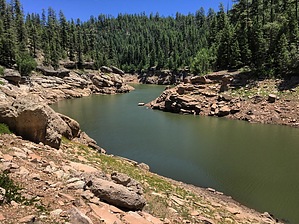
Rock Crossing Trail #18 is split into three segments because it crosses Blue Ridge / C.C. Cragin Reservoir two times.


Segment #18A goes from FR751 near Rock Crossing Campground and descends 1/2 mile to the lake (-420ft). This is the most frequently used trail segment.
remove free decal offer
See also Segment #18B

See also Segment #18C


    Check out the Official Route and Triplogs.
    Leave No Trace and +Add a Triplog after your hike to support this local community.

    One-Way Notice
    This hike is listed as One-Way.

    When hiking several trails on a single "hike", log it with a generic name that describes the hike. Then link the trails traveled, check out the example.
    WARNING! Hiking and outdoor related sports can be dangerous. Be responsible and prepare for the trip. Study the area you are entering and plan accordingly. Dress for the current and unexpected weather changes. Take plenty of water. Never go alone. Make an itinerary with your plan(s), route(s), destination(s) and expected return time. Give your itinerary to trusted family and/or friends.

     Permit $$
    None


     Directions
    or
     Road
    FR / Dirt Road / Gravel - Car Okay

    To hike
    From Clints Well go north on Highway 87 to FR 751 (about 4 miles, approximate milepost 295.2) and turn right (southeast). Drive about 3.6 miles to the trailhead located on the right side of the road.
    page created by chumley on Oct 14 2013 6:46 pm
     90+° 8am - 6pm kills
    helpcorrectionissue

    end of page marker