| Guide | ♦ | 4 Triplogs | 0 Topics |
details | drive | no permit | forecast | route |
stats |
photos | triplogs | topics | location |
| 23 | 4 | 0 |
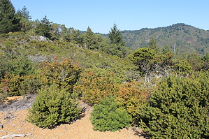
Wild and Serpentine by JimmyLyding The trailhead is across the Bolinas-Fairfax Road from a small parking area, and it immediately begins to gain elevation. The first section of the Pine Mountain Fire Road covers about a mile, and provides a good introduction to the serpentine geology that's common in the area. Serpentine is low in nutrients and high in heavy metals which means only a few plants can survive here. Here you see Sargent's cypress which is a small conifer that closely resembles a juniper. Most specimens only grow to about 10' or shorter out of the dense chaparral. The first mile and 400' of gain reach a junction that leads to Carson Falls 0.7 mile away, then a further half mile leads to a junction with the San Geronimo Ridge Road. These roads are fire roads which means there are no vehicles, but occasional mountain bikers. Go left to stay on the Pine Mountain Road to continue on to Pine Mountain.
Continue on Pine Mountain Fire Road as it drops down to about 400' above sea level and the forest closes in. The birches and tanoaks that replace the chaparral give way to redwoods and Douglas firs. You'll notice Kent Lake, a reservoir that supplies drinking water to the urban portion of Marin on the east side of the peninsula, a few hundred feet below to the north. The dirt road goes almost 5.5 miles as it winds along an arm of the lake before following Big Carson Creek, crossing it, and winding up to San Geronimo Fire Road on top of Big Carson Ridge. The bottom of the Big Carson drainage has second-growth redwoods (and bugs), then the chaparral reappears as the route travels higher. It's about 9 miles to this point, but there are plenty of more steps ahead. Go right/east on the San Geronimo Fire Road all the way back to the Pine Mountain Fire Road after passing the Conifer Fire Road (1 mile), Bay Area Ridge Trail, then Cascade Canyon Road (dirt, primitive) 2.5 miles further. This area has similar vegetation to the beginning, but also has dense thickets of short Sargent's cypress. A half mile later leads to the Pine Mountain Fire Road, and continue another 1/3 mile to another junction before bombing downhill on the original trail that goes 400' and a mile down-up-down to the trailhead. Check out the Official Route and Triplogs. Note This is a moderately difficult hike. Leave No Trace and +Add a Triplog after your hike to support this local community. | ||||||||||||||||||||||||||||||||||||||||||||||||||||||||||||||||||||||||||||||||||||||
 Route Editor


