Route Editor

| Guide | ♦ | 2 Triplogs | 0 Topics |
details | drive | no permit | forecast | 🔥 route |
stats |
photos | triplogs | topics | location |
| 16 | 2 | 0 |
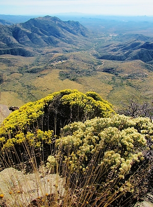
scratches, bruises and discomfort by black_toes   This is a bushwhack through pristine chaparral to the 5,763' summit of a long, flat mesa with spectacular views to the desert floor on the south and distant Wickenburg, thousands of feet below. The trek is short but demanding, yet the reward is great if you enjoy hiking where few others have trod. This is a bushwhack through pristine chaparral to the 5,763' summit of a long, flat mesa with spectacular views to the desert floor on the south and distant Wickenburg, thousands of feet below. The trek is short but demanding, yet the reward is great if you enjoy hiking where few others have trod.Finding it Antelope Peak rests on the east edge of the small town of Yarnell. I found no one there who knew the name of the peak, much less a way to get to the top of it. There is no trailhead and surprisingly no trails. You're on your own. From 89 in town, I drove east up nearby Happy Way toward the easily recognized mesa. After two blocks, Happy Way morphs into a service road to cellphone towers on a small peak on the right. At a hairpin curve 1/2 mile up the road, I parked in a small turnout beneath Antelope Peak and started.
I quickly came up with a general plan for the ascent. I would follow a contour on Antelope's western flank, and reaching a ridge to the north; I would turn back southeast on the spine to the summit. Easier said than done. I soon encountered large obstacles of scrub oak, 3-5 feet high, high grass, and cactus that required detours. And every step was a step on a rock, large and small. A quarter-mile up the contour, I ran into a taut barbwire fence. It took 15 minutes to find a place to crawl under it. Several interesting cactus and wildflowers along the way to take my mind off the slog, including a large cluster of King's Cup Hedgehog and patches of globemallow. It is a beautiful, wildland. On top of the ridge, at a 1/2 mile out, you can look back to the west to see Yarnell and the big burn zone, where 19 firefighters died last summer in the Yarnell Hill Fire. I started up a steady rise of the spine from the northwest. It took an hour from where I parked the car to reach the summit, a long rocky ledge overlooking a cliff. I walked a quarter-mile along this rocky ledge, and according to my GPS, there was a variance of only six feet from west to the slightly higher east end. You can look south forever, it seemed. Rich Hill and the old ghost town of Stanton are directly below with Wickenburg in the distance, about 3,500' down on the desert floor. There is no sign that any human had been up here before me, although I'm sure there have been. It was worth all the scratches, bruises, and discomfort coming up, a rare hike. Check out the Official Route and Triplogs. Leave No Trace and +Add a Triplog after your hike to support this local community. | |||||||||||||||||||||||||||||||||||||||||||||||||||||||||||||||||||||||||||||||||||||||||||