 Route Editor

| Guide | ♦ | 12 Triplogs | 0 Topics |
details | drive | permit | forecast | route |
stats |
photos | triplogs | topics | location |
| 94 | 12 | 0 |
It might make you cry by Hippy   Overview OverviewThe Toroweap Trail is an old miner's route starting from the "Cinch Up" at the top of Bright Angel Trail. The route traverses along the Toroweap formation for roughly 2 miles until reaching the upper section of the now-abandoned Orphan Mine. WARNING This is not a trail. Only hikers who are experienced in off-trail exploration in the Grand Canyon should attempt this route. Route-finding can be a challenge, and this route requires ample class-3 scrambling along poor surface conditions with exposure. A misstep on this route could result in severe injury or death.
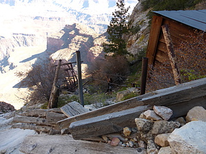
Dan Hogan initially opened the Orphan Mine (an orphan, hence the name) in the 1890s as a Copper Mine. Mining went on for a few years and then stopped. Uranium was then discovered in the 1950s and was mined from 1953 to 1972. Over those years, the Orphan Mine produced 13 million pounds of Uranium. The National Park Service acquired the patent in 1963, but the operator retained the extraction rights until 1988. There is not much remaining of the Orphan Mine today. All of the structures on the rim have been removed, and there is still some evidence below the rim. There is a discussion on clearing the rest of the site, but those details are still pending. Hike The start of the route is obvious as you follow along the base of the cliff. As you proceed, the route will wrap around to the northern side, where fewer people travel due to the risk involved in crossing two steep, ten-foot sections of exposure. The first ten-foot section is a steeply angled path with no trees or rocks to protect you from sliding right over the edge of the 400+ foot Coconino cliff. The edge of the cliff is anywhere from 3-5 feet below your tiny catwalk. It's easier than it sounds. Once across this section, there is a tree and a rock that offer a safe haven. From there, continue to the next not-so-sketchy section. These are the sketchiest sections of this route. Afterward, you’ll cross another open and unprotected path for about ten feet and then head down into a wonderfully hidden micro-climate full of Douglas Firs and Pines. Hidden up behind the thick trees is an alcove thought to hold Mountain Lions and Bobcats. If you look up through the trees in the Micro-Climate, you can clearly see Maricopa Point viewpoint a few hundred feet above. As you near the section directly below the viewpoint you will see an obvious path wedged upright to the cliff, Don't Go There! It cliffs out, and you'll have to backtrack a few minutes while negotiating the soft and slick scree in the area. You want to head down below that obvious footpath about 50 feet. There is a large Cairn placed high up on a ledge, don't go directly to it. You'll have to use your route-finding skills to locate the path down the ravine well below that cairn. Once you spot it, you'll be able to safely wrap around the northern point where you’ll then see the Orphan Mine, telephone lines, Tram Operator Station, and Powell Point up on the Rim. The Toroweap Trail will take you almost directly to the abandoned Tram Operator's Station, which sits snuggly atop the Coconino Cliff; use caution here. One slip, and you'll free fall a good 400+ feet. Use caution when exploring this area and enter buildings at your own risk. From the abandoned station, head up the hill, where you'll soon spot the Upper Hummingbird trail on the right-hand side. It’s marked the entire way with pink whisker markers sticking up out of the ground. Follow the markers as it switchbacks up to the rim on the west side of the draw. You will exit onto the rim on the inside of the fenced-off area where the old Orphan Mine buildings once stood. Throughout this entire hike, there are no signs saying do not enter or no trespassing until you reach the point where the Old Rim Trail intersects with the current Rim Trail; exiting is OK, just don't enter the way you came. Hence this is a one-way hike. Check out the Official Route and Triplogs. Leave No Trace and +Add a Triplog after your hike to support this local community. One-Way Notice This hike is listed as One-Way. When hiking several trails on a single "hike", log it with a generic name that describes the hike. Then link the trails traveled, check out the example. | ||||||||||||||||||||||||||||||||||||||||||||||||||||||||||||||||||||||||||||||||||||||||


