When hiking several trails on a single "hike", log it with a generic name that describes the hike. Then link the trails traveled, check out the example.
WARNING! Hiking and outdoor related sports can be dangerous. Be responsible and prepare for the trip. Study the area you are entering and plan accordingly. Dress for the current and unexpected weather changes. Take plenty of water. Never go alone. Make an itinerary with your plan(s), route(s), destination(s) and expected return time. Give your itinerary to trusted family and/or friends.
Permit $$
None
Directions
Road
High Clearance possible when dry
To hike From AZ-260 and the Rim Road (FR300) travel west on FR300 for 8.5 miles. Turn right onto FR169 (Chevelon Ridge Road) and travel for 7.5 miles. Turn right onto FR119 and travel 1.5 miles. Turn left onto FR180 and travel 3.0 miles. Turn right onto FR180B and park a hundred yards down hill at the road's end.
 Route Editor

 This trail provides easy access to the head of Chevelon Canyon Lake (southern end).
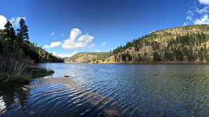


