 Route Editor

| Guide | ♦ | 14 Triplogs | 0 Topics |
details | drive | no permit | forecast | map |
stats |
photos | triplogs | topics | location |
| 60 | 14 | 0 |
Step Back In Time... by imike The surrounding mountains provided the timber for the wooden buildings. Cloudcroft’s new Cloud Climbing Railroad was pumping logs down the hill to the local mills.
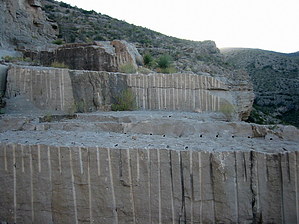
Some of the rock did a bit more. Just inside the mouth of Marble Canyon was a deposit of higher grade marble… 1700’ long… 80’ thick. (…history book listed 17,000’ long, but I think they zero’d an extra). It was noted for its high gloss quality. There is a reference about the mine operating round the clock in 1907. The pictures I could find of the operation show a huge drag line boom… and little else in the way of machinery. There are still remains of the huge metal cable and the eye bolt anchors sunk into the towering cliffs. Today, the tumble of rock slabs scattered over the lower slopes show the tell-tale bore holes drilled to facilitate splitting them off from the mountain side… those half slices nicely matching the half slice remaining on the bulk wall slabs. Some of the partially processed slabs lie on rotting timbers, leveled, ready to be recut into manageable pieces for hauling into town. The only remaining evidence of this finished marble lies in the local cemeteries. There was one building constructed of this fine stone; it was demolished to make way for a bank building some years ago. In addition to the cables and cuts, if you crawl around the works enough you will discover one of the old drilling rods hammered into the stone… along with a splitting wedge. That process of drill and wedge is still in use today. This is a shorter hike… but when you factor the distance you get to travel back in history, it is pleasantly satisfying. From the parking area near the Firestation on 10th you will walk south over into the mouth of Marble Canyon, then a short distance up canyon. The Quarry immediately comes into sight on your left. The remains of the old access road are also to your left; it is washed out but does provide an easier approach to the upper reaches of the mine. Climb out of the canyon bottom and wade through the bushes to take advantage of this easier route. Once up into the slabs you will have to do a bit of scrambling to access the upper reaches. This area should be considered dangerous. Back during the active years, one of the operation managers took a misstep, fell… and died from his injuries. Stay Safe! The access into this area is across private property. At this time there are no problems with the landowners; treat the hike with respect and it should stay that way. At the far upper east end of the Quarry is the Quarry Canyon hike that you could use to loop over to Trail 119. An Oldy but a Goody. Check out the Triplogs. Leave No Trace and +Add a Triplog after your hike to support this local community. One-Way Notice This hike is listed as One-Way. When hiking several trails on a single "hike", log it with a generic name that describes the hike. Then link the trails traveled, check out the example. | |||||||||||||||||||||||||||||||||||||||||||||||||||||||||||||||||||||||||||||||||||||||


