Route Editor

| Guide | ♦ | 14 Triplogs | 1 Topic |
details | drive | permit | forecast | route |
stats |
photos | triplogs | topic | location |
| 176 | 14 | 1 |
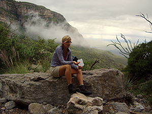
Bottom to Top... by imike For a very simple and super scenic experience, simply enjoy hiking up as far as you desire and turn around to enjoy the downhill trek back to the car. The views in reverse are exceptional, and that is what the lower half of this hike is all about: fantastic views, ever changing with the elevation and more over, the weather.
T106 gains altitude steadily as it winds up through what most consider the most scenic canyon in the Sacramento Mountains... with gradients up to 25%. 2.9 miles up the trail, the route drops down and crosses the canyon drainage, and you will encounter the ruins of an historic stone cabin. If the seasonal rains are in force, you will gifted with some spectacular waterfalls above the cabin site... From this point on, the trail climbs more steeply up to and along the towering cliff edges of the canyon. Gradients may average 20% to 50%, with uncertain footing along some of the areas, but the climb is well worth the effort. As you move below the prominent cliff known as the Eyebrow, the views of the surrounding canyon and the valley far below reward you with a well earned vista. The trail moves along and past then up and over and out of the canyon proper, taking you to a meadowed shelf above the cliffs... and climbing into scrub forests. At mile 5.5 you reach the end of T106, and turn right on to Forest Road 90B. Following F90B for 2.9 miles takes you to the intersection of F90 and the trail connection to T234 immediately across the road. This trail will climb you up through the Pines and mixed hardwoods to the very top of the mountain range. After 1.6 miles this very steep trail will terminate at the Old Sunspot Road (T105B) where you will turn left and follow the old roadbed around to a gated fence. At the fence, turn to the right, following the fence over to a pedestrian gate. At the gate you are in site of and 100 yds from the visitor center on top of Sacramento Peak.. and in the Sunspot Solar Observatory complex. Enjoy the museum displays at the visitor center... restock on water and fluids or snacks from their machines... buy a souvenir from their gift shop. Use the nice flush toilets! Rest up and head back down the trail to round out the day. Or, hop into your car that someone shuttled up for you! The area guidebook lists this route as too difficult to do bottom to top, and suggests that it is better to be dropped off on top and hike the route down to the bottom. It is a steep trail. To attempt the bottom to top route requires a conditioned and motivated hiker, but still, the full up/down is very doable and rewarding. At age 60 I do this circuit with an additional 9 mile loop added on top to stretch the day out to a round 30 miles... and manage that within ten hours total. It is probably best to first test hike sections of this route before attempting the entire route. It does have the advantage of being served by intersecting roads: F90 midway... Sunspot Hiway on top. Winter months could find the upper reaches snow bound. Summer months will find days into the 100's at the lower end. Also... for those putting in the nice long day, Oliver Lee State Park has hot showers! That feature really rounds out the day. There is a day use fee for parking in the park. Camping is also available with trailer and tent sites. Reservations may be made for desired spaces. Gate Policy: If a gate is closed upon arrival, leave it closed after you go through. If it is open, leave it open. Leaving a closed gate open may put cattle in danger. Closing an open gate may cut them off from water. Please be respectful, leave gates as found. The exception is signage on the gate directing you otherwise. Check out the Official Route and Triplogs. Note This is a more difficult hike. It would be unwise to attempt this without prior experience hiking. Leave No Trace and +Add a Triplog after your hike to support this local community. | |||||||||||||||||||||||||||||||||||||||||||||||||||||||||||||||||||||||||||||||||||||||||||||||||||