Route Editor

| Guide | ♦ | 25 Triplogs | 1 Topic |
details | drive | no permit | forecast | 🔥 route |
stats |
photos | triplogs | topic | location |
| 537 | 25 | 1 |
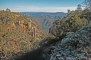
Hang on for a tooth jarring, butt kicking ride by AZLumberjack  Overview OverviewA scenic, one-way 4x4 trip down a historic road through the remote Sierra Ancha Wilderness. The road passes through canyons, washes, forests, and open grazing lands. Most sections of this road were "etched" high into the side of the canyon walls many years ago to open the area to mineral exploration, lumbering, and ranching. Warning This road is strongly recommended for high clearance, 4x4 vehicles with the emphasis on "high clearance" such as Jeep and All-Terrain Vehicles (ATV/UTV). Further, it would be wise to include a winch and tow straps to winch boulders and/or trees from the road or your vehicle back onto the road. The entire area is "out of range" for cellular phones and AAA wouldn't come out here on a bet. Road maintenance has long since ceased on the Northern half of the road, travel is at your own risk. Travel on this road is not advisable during the Monsoon Season. Long wheelbase 4x4's (Suburban, etc) are not recommended.
This 40-mile road passes through some of the most remote and inaccessible terrain in Arizona. Many of the canyons feeding into the main Cherry Creek Canyon are known to have centuries-old cliff dwellings hidden high on the walls tucked under protective overhanging cliffs. Around the year 950 AD, a new people, called the Salado, appeared and settled in the area we know today as the Sierra Ancha's. These people built their multiple-family dwellings high above the floor of the 4,000 ft deep canyons to better ward off attacks from outside warring elements. Access to these dwellings is extremely hazardous but doable and they should be treated with the utmost respect when approached. Remember, this is our heritage, once it's gone, it's gone forever. Other activities in the area included mining for minerals such as Uranium and Asbestos. Many of these now-abandoned mines have open shafts and tunnels that can be explored. These mining areas are hazardous and caution should be exercised, remember, help is a long way off. Hike Several hikes begin from the road, most lead to cliff dwelling locations while others are scenic loop hikes. Check the list of HAZ hikes in the area, most are complete with GPS routing. Remember to allow yourself enough time to complete the hike and still be able to safely exit the canyon before darkness sets in as this can be highly difficult to travel with only headlights to lead the way. Water Sources Many of the canyons that feed the Cherry Creek Drainage have some flowing water and several have springs a short distance from the road. Remember, this is cattle country and livestock isn't too particular where they defecate. Look around the area of the spring before sampling the "cool-clear" and filtering is the preferred method. Camping Many of the large side canyons feeding into the Cherry Creek canyon have suitable camping areas alongside the road and many of these camping areas are suitable for overnight. Further, there is an abandoned cabin at the P B Ranch (Coordinates: 33 deg. 56.2317 by -110 deg 55.5445) This cabin is well maintained by the campers who use it and is complete with two beds, a kitchen table, cooking stove (if there is LP on site), a sink for doing dishes and it's even carpeted. The cabin sits alongside a perennial stream where water may be drawn for dishes/cleaning or filtered for drinking. The Trip Three persons and day hiking gear were packed into a Toyota FJ Cruiser SUV for this day trip from end to end of FR-203 (Cherry Creek Road). Our trip started at the Northern terminus of FR-203 (Coordinates: 33° 58.107 by -110° 57.1217) and AZ Hwy 288, about 14 miles south of Young, AZ. The hard-packed dirt/rock road is well marked and easy to follow with side roads equally well marked along its length. The road quickly descends from the 6,000-foot plateau for about 500 feet of exciting switchbacks and assorted 180s then levels off (?) to a more gradual descent as you alternately crane your neck to look up at the steep cliffs rising on your right to views of the distant opposite canyon on your left and the valley running down the middle. It may be difficult at times but you gotta remember to keep your eyes on the road ahead and there are no signs to warn of sharp curves or the often encountered "Fallen Rock". We were occasionally shaken out of our scenery observing mode by the sharp clunk of a boulder hitting the skid plate under the FJ. The trip is a truly "sensory overload" experience as you bounce along the boulder-strewn road that alternates through pine forest, grassy meadows, extremely vertical cliffs and an occasional peek at the creek several hundred feet below. Stopping from time to time is mandatory to exit the vehicle and feast your eyes on the 360-degree views that abound everywhere you look. It's easy to let your mind wander and imagine how the ancient inhabitants of this harshly beautiful canyon lived and worshiped. Signs of wildlife are in abundance, water is readily available and plots of land are suitable for growing crops, so, why did they disappear so suddenly? We finally rounded a curve in the road that presented us with a view of an old rustic cabin with a tin roof, rickety porch, and curtains hanging in the in-tact glass windows. It was shortly after noon so we exited the road, down a rough two-wheel track that led across a flowing, boulder-strewn creek to a large clearing beside the cabin. Cameras at the ready, we wandered around the clearing taking note of a severely dilapidated log cabin that was now little more than a pile of old cut logs covered with rusted tin roofing and brush. A memorial to a deceased Viet Nam Veteran was nailed to a large tree near the log cabin and a US Flag fluttering in the light breeze. As we approached the newer cabin, we could see the names of previous visitors etched into the fading rough-cut wood siding, wind chimes hanging above the porch, and a comfy camping chair waiting for the next occupants. The inside of the cabin was amazingly clean, even the beds were made as if expecting company to drop in at any time. The pantry had a wonderful selection of canned goods stocked on the shelves, pots and pans hung from rafters where varmints couldn't get into them and even a partially full tank of LP was there for cooking on the old gas stove. After a quick lunch, it was back into the FJ and the bouncy rough road that led past a seemingly infinite number of canyons. There are no signs to announce the names of the canyons so it's a good idea to bring along a detailed map of the area or a GPS with detailed TOPO maps loaded. With the right "tools" on hand you can soon associate canyons with names like, Cold Water Canyon, Deep Creek, Gold Creek, Billy Lawrence Canyon, Pueblo Canyon, Cold Spring Canyon and Devils Chasm. If you have made it this far without having to move boulders or tree trunks to continue, then the rest of the trip is a piece of cake. Once past Ellison Ranch the road crosses Cherry Creek a couple of times and turns into a fast although boring 19 mile trip to its terminus with 288 again just above the narrow bridge crossing the Salt River. We completed this trip in November with Autumn Color easy to be found in the bottoms of deep wet canyons. Check out the Official Route and Triplogs. Leave No Trace and +Add a Triplog after your 4x4 trip to support this local community. | |||||||||||||||||||||||||||||||||||||||||||||||||||||||||||||||||||||||||||||||||||||||||||||||||||||||||||||||||||||||||||||||||||||||||||||||||||||||||||||||||||||||||||||||||||||||||||||||||||||||||||||||||||||||||||