Route Editor

| Guide | ♦ | 7 Triplogs | 0 Topics |
details | drive | no permit | forecast | map |
stats |
photos | triplogs | topics | location |
| 19 | 7 | 0 |
Canyons are inherently risky. Flash floods occur without notice on sunny days. Technical skills & surrounding topography knowledge required yet does not eliminate risk.
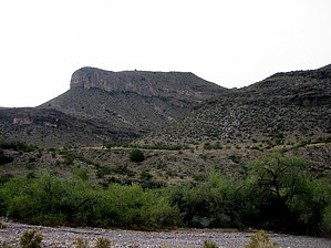
The Best Way to Meet the Lady by imike  Walking up T104... Just a bit over half mile, at the junction with the Roundup Grounds Trail (T107), Deadman Canyon takes off on your right, heading east. A few hundred yards of walking up Deadman will deliver you to the mouth of Rock Spring Canyon on your right.
Around half mile up, you will reach the namesake springs, seeping into a pool out of the rock basin. Just above the lower springs you’ll note a young cottonwood tree attempting to grow from the rock. A bit further up and you will reach a very nice dry falls blocking your access. The fall is climbable. If you’d prefer a safer route, move to your far right and make your way up the obvious cleft hiding a game trail access up to the next level. At this point the drainage splits… the “real” channel is on the left. The better alternative is to exit the bottom of the canyon and follow the distinct game trail up the ridge between the two branches. This trail makes for easy access, ever steeper, up and out of the lower canyon basin. At the top of this center ridge, you will find yourself turning to the left to follow the main canyon… opting to either continue to walk the side of the hill… or drop back down to hike in the canyon bottom. The canyon will continue to climb and curve, not ending until it reaches the saddle just below the very distinctive Steamboat formation. At that point you can walk to the west and gaze down into the upper reaches of Black Canyon… or make your way on up to the base of the Steamboat. You will be standing on the formation known as “the Lady”… as viewed from anywhere in Alamogordo. This hike is likely the best access to reach this prominence. From up here you do have some looping options: check out Deadman/Rock Spring Ridge… descend around and down into Deadman South… traverse over to Deadman North and the Roundup Grounds trail… descend into Black Canyon… ascend up and around the Steamboat… or go ridge wandering in general. The easy way home is the way you came. Check out the Triplogs. Leave No Trace and +Add a Triplog after your canyon trip to support this local community. | |||||||||||||||||||||||||||||||||||||||||||||||||||||||||||||||||||||||||||||||||||||||||||