username
X
password
register
for free!
help
 

Sotol Canyon Shortcut, NM

Guide 1 Triplog  0 Topics
  2 of 5  
Fav
Wish
0
details
drive
no permit
forecast
map
stats
photos
triplog
topics
location
18 1 0
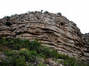
Canyons are inherently risky. Flash floods occur without notice on sunny days. Technical skills & surrounding topography knowledge required yet does not eliminate risk.
Statistics
tap row or icons for details
Difficulty 3.5 of 5
Route Finding 3 of 5
Distance One Way 1 mile
Trailhead Elevation 4,809 feet
Elevation Gain 635 feet
Accumulated Gain 650 feet
Avg Time One Way 1 hour
Kokopelli Seeds 3.17
 Interest Off-Trail Hiking & Seasonal Waterfall
 Backpack Possible - Not Popular
 Dogs not allowed
feature photo
Photos Viewed All MineFollowing
18  2013-11-18 imike
Author
author avatar Guides 253
Routes 0
Photos 6,930
Trips 2,467 map ( 21,513 miles )
Age 75 Male Gender
Location Cloudcroft, NM
Historical Weather
Trailhead Forecast
Expand Map
Preferred Apr, Mar, Oct, Nov
Seasons   ALL
Sun  5:43am - 6:18pm
0 Route
 
0 Alternative


Sticky, Prickly, Tumbly...
by imike

Sotol Canyon is the first side canyon (on your left) as you enter Marble Canyon. It cuts across the old access road that leads up to the Marble Quarry. For all practical purposes, it well could be avoided; it is overgrown, filled with loose rock over unstable dirt... and, it is way steep. The way steep part might be its saving grace for some hikers.


As the leading leg of a loop, it can provide an interesting bit of training. Moving very slowly and with great caution (and you better be doing both) your heart rate may still be ranging into the upper cardio levels. As you work your way up and around the various obstacles you will score a great workout. While it is a shortcut over to the "A" trail, it does not allow you to get over there fast. This is a slow route.
remove free decal offer
It does wind up and over to connect with that other trail. If you desire a simple two hour loop and do not feel like pushing the pace, just making your way around this narrow canyon will get the job done.

You have the option of making your way along the bottom of the rocky cut, often overgrown... or, try to follow one of the numerous game trails that work their way around and up.

The canyon splits and spans out to a broad basin after your climb through the lower cliffs. The far left branch remains the steepest. The right side provides an easier approach. Eventually, you will want to move to the far right of the drainage where you will encounter Trail 119 ("A" Trail) as it passes some old excavations. At this point you are about 1.1 mile from the trail head and 700' up from that level.

You could head down, or consider going higher and looping around and down the Quarry Canyon, looping you back to the Marble Quarry.


I did it once... you might as well, too!

Note: you cross private property making your way up and into Marble Canyon. Be quiet and respectful of this privilege.

2013-11-19 imike


    Check out the Triplog.
    Leave No Trace and +Add a Triplog after your canyon trip to support this local community.
    WARNING! Hiking and outdoor related sports can be dangerous. Be responsible and prepare for the trip. Study the area you are entering and plan accordingly. Dress for the current and unexpected weather changes. Take plenty of water. Never go alone. Make an itinerary with your plan(s), route(s), destination(s) and expected return time. Give your itinerary to trusted family and/or friends.

     Permit $$
    None


     Directions
    or
     Road
    Paved - Car Okay

    To canyon trip
    Park at the City Park (next to the Firestation) at the far east end of 10th Street in Alamogordo. From the park, walk south across the gravel lot, over and into the mouth of Marble Canyon. Turn to your left, follow the canyon bottom until you see the Sotol canyon coming in on your left... just before the Marble Quarry.
    page created by imike on Nov 19 2013 3:03 pm
     90+° 8am - 6pm kills
    helpcorrectionissue

    end of page marker