Route Editor

| Guide | ♦ | 2 Triplogs | 0 Topics |
details | drive | no permit | forecast | map |
stats |
photos | triplogs | topics | location |
| 56 | 2 | 0 |
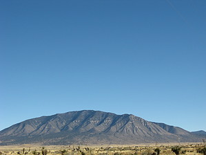
Carrizozo's Peak by Jim Proceed up O-Bar-O Road or Forest Road 441, to the Johnnie Canyon Trailhead, which is marked with a nice obvious sign. This trailhead is the start of a few local trails. My Subaru made the trip easily, with snow, mud and rock on the last mile. My old sedan might have gotten to within a mile of that point. Any major 4x4 will be fine, but you'll need some clearance to get all the way in.
About two-thirds of the way up canyon, a seep spring is encountered. This was the only water source I encountered, and it may not be there in dry months. It can be filtered, when present. Beyond the spring, the trail continues until you cross a small grassy meadow and shortly thereafter, a series of switchbacks take you up to the first saddle. This first saddle is where you reach trail # 72, the Carrizo Peak Trail. The trail heads west on the shady north side of a lesser peak, and reaches a second small saddle. Some elevation is lost in this section, but after the saddle you climb steadily up towards the peak via a series of switchbacks that bring you up to the signed summit. There are several rolling summits, with one just north of the oak thicket offering the best views to the north. Return the way you came. Check out the Triplogs. Leave No Trace and +Add a Triplog after your hike to support this local community. | ||||||||||||||||||||||||||||||||||||||||||||||||||||||||||||||||||||||||||||||||||||||||||