 Route Editor

| Guide | ♦ | 4 Triplogs | 0 Topics |
details | drive | no permit | forecast | map |
stats |
photos | triplogs | topics | location |
| 0 | 4 | 0 |
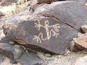
397 rock art panels by autumnstars  A short hike to a world-class petroglyph gallery. The majority of hiking is up a gently-sloping gravel wash, whose volcanic walls increase in height and steepness to form a narrows. Many of the petroglyph panels occur within and shortly above these narrows. Warning There are four dry falls to climb, with the last being the most difficult (~10 ft boulder chalk). If you are uncertain of your ability, instead use Trail 200 (Cowboy Trail) to access the upper reaches of Petroglyph Canyon. Also, this is not a wise place to be during rain.
The Sloan Canyon site is located in the northwestern McCullough Range, south of Las Vegas. Although the petroglyph gallery was added to the National Register of Historic Places in 1978, the area was only recently designated as Sloan Canyon National Conservation Area (NCA) in 2002. As of 2002, Petroglyph Canyon itself is further protected within the North McCullough Wilderness. Archaeological surveys conducted since 1997 indicate that the Sloan Canyon area has evidence of Middle Archaic, Late Archaic, Puebloan, and Late Prehistoric occupation. In total, surveys have documented 397 rock art panels, the majority located within Petroglyph Canyon. Abstract motifs (almost 90% of total motifs) and representational forms are both present. Milling slicks are associated with some of the petroglyphs. Hike From the post-and-cable barrier across the wash, walk up to the sign where you can read a bit about the area. Be sure to sign in since recorded visitation is one way the BLM decides how to divvy up funds. From here, walk up the wide gravel wash as it opens up and the walls become lower. Gradually, the surrounding volcanic slopes move closer and become much steeper as you continue up wash. Continue left at the sign to remain on Trail 100. The wash narrows further with each dry falls. Be sure to keep a sharp eye on the side walls, as this is where the first petroglyphs come into view. The density of images increases as you continue up-canyon, peaking just at and shortly above the last dry fall (aka, the narrows). The easiest way up the last dry fall is to the left of the boulder chalk, but not all the way against the wall. Both sides of the wash are heavily covered here, so take your time and really enjoy. Continuing beyond this point, the majority of images are on large wash-side boulders. The wash begins to open up again as you approach the end of the trail. Trail 100 ends at a sign indicating the intersection with Trails 200 and 300. You can continue up Trail 300 (more petroglyphs) or return via Trail 200 or Trail 100. Check out the Triplogs. Leave No Trace and +Add a Triplog after your hike to support this local community. One-Way Notice This hike is listed as One-Way. When hiking several trails on a single "hike", log it with a generic name that describes the hike. Then link the trails traveled, check out the example. | |||||||||||||||||||||||||||||||||||||||||||||||||||||||||||||||||||||||||||||||||||||


