 Route Editor

| Guide | ♦ | 2 Triplogs | 0 Topics |
details | drive | no permit | forecast | map |
stats |
photos | triplogs | topics | location |
| 23 | 2 | 0 |
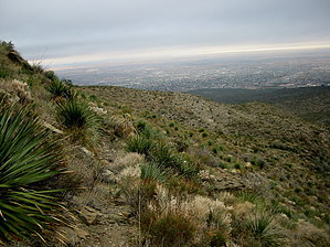
Hold the High Ground! by imike  There are a couple of connecting routes that can carry hikers up and out, but those orient to the Southeast… all linking to The Ortega/Dry Canyon Traverse.
The best chance of that happening: Mineral Ridge. The Ridge lies between Mineral Springs Canyon and Mineral Springs Canyon North in the mid regions. Above Mineral Springs it ranges on the south side of Mineral Springs Canyon North. Below the Springs, the Ridge is designated as Dark Mesa. This multi-tiered ridge walks with relative ease… sometimes overgrown, but usually allowing a winding passage ever up. The various levels of ledges and cliffs never cut off passage. Eventually, the Ridge cliffs out below Winter Peak on Horse Ridge. While it is easy to hike the lower section, Dark Mesa, the more practical section begins as Mineral Springs Trail (T5579) winds up and over the Ridge… just as the trail drops over into Mineral Springs Canyon (at the metal water tank). Instead of walking down past the tank, continue up the middle of the ridge. You’ll note an old horse trail cutting its way up through the lower ledges. The horse trail has not been used in decades… but its old rut will carry you for awhile. Eventually, you will have to make your own way. The southern side of the slope tends to be more overgrown… drift to the north for a clearer route. This is off trail. Take your time and enjoy! Note: You can hook up with the upper portions of The Mineral Springs Trail (to the south) for most of the upper mile. You can access the very interesting upper regions of Mineral Springs Canyon North at any time by working your way around to your left. Be careful if you decide to descend down that drainage. So... for a short off trail trek... or a push to the top and out... this ridge just might be the ticket? Check out the Triplogs. Leave No Trace and +Add a Triplog after your hike to support this local community. One-Way Notice This hike is listed as One-Way. When hiking several trails on a single "hike", log it with a generic name that describes the hike. Then link the trails traveled, check out the example. | ||||||||||||||||||||||||||||||||||||||||||||||||||||||||||||||||||||||||||||||||||||||||||


