Route Editor

| Guide | ♦ | 10 Triplogs | 0 Topics |
details | drive | no permit | forecast | map |
stats |
photos | triplogs | topics | location |
| 47 | 10 | 0 |
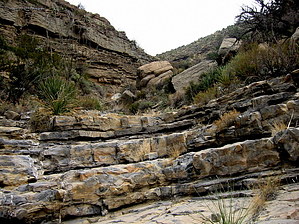
Canyons are inherently risky. Flash floods occur without notice on sunny days. Technical skills & surrounding topography knowledge required yet does not eliminate risk.
Do It Twice! by imike  The better way to hike to the Springs is to access this canyon at the bottom… or where the official trail first crosses this drainage about a mile into the hike. Either approach offers a more interesting hike.
Eventually, if the Springs are your goal, you’ll exit the canyon as the trail winds its way up and across Mineral Ridge. It is easy to spot this early exit point: the canyon suddenly gains a high cliff on the right. The trail is to your right immediately before that landmark. In fact, the trail is just 50-100’ away from the canyon for most of the second mile. Walk out and over to the old jeep track at any time. This lower section is easy... fun for anyone. Upper Canyon: From this point on, it is a different canyon. The Class II Canyoneering kicks in. The cut narrows and deepens. The rock gets interesting. The scrambles become constant. It is just nice up in there… and goes and goes. Within the first mile you will begin to encounter successive dry waterfall formations, undercut… they will force you to access side routes to skirt around. Eventually, the progress becomes so slow you’ll likely decide it is not worth it to climb higher. Don’t turn around too soon… there’s good stuff the higher you go. Once up, you can opt to descend via the canyon… or move south around the side ridge to access Mineral Ridge. It walks nicely down, offering a touch of variety to the hike. This is a hike worth checking out. Do the lower... Do the upper. Twice as Nice Note: The Levee diverts the water draining out of The Basin... the easy way to find the bottom of this canyon: walk south along the levee... the ditch on your left is effectively the canyon bottom. When the ditch wall curves to the East, that is your mark. Turn left and follow the drainage across the flat area... across the pipeline road and on into the canyon. Check out the Triplogs. Leave No Trace and +Add a Triplog after your canyon trip to support this local community. | ||||||||||||||||||||||||||||||||||||||||||||||||||||||||||||||||||||||||||||||||||||||||