Route Editor

| Guide | ♦ | 7 Triplogs | 0 Topics |
details | drive | no permit | forecast | route |
stats |
photos | triplogs | topics | location |
| 120 | 7 | 0 |
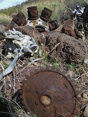
God is My Co-Pilot by AZWanderingBear  History HistoryWarner Brothers filmed aerial combat shots for "God Is My Co-Pilot" in 1944 near Lake Pleasant. Several North American AT-6 Texans were repainted to resemble Japanese Zeros. One of the AT-6's ( pilot: 2nd Lt. Orland Luhr ) crashed into the wing of a B-25 Mitchell bomber ( onboard: 1st Lt. George Hunter, 2nd Lt. Patrick Holland and Sgt. James Ramey ).[1] Overview This hike takes you overland and off-trail for 3.5 miles to the crash site of the AT-6 Texan. Lt. Luhr's remains were removed from the crash site, but most of the airplane's wreckage remains. The hike is off-trail and requires decent navigation skills and lots of bushwacking.
Drive to the Lake Pleasant Marina but don't enter. Continue north on the road until you reach a gate across the road. Park on the southeast side of the gate N33 51.107 W112 14.796. There is plenty of room. Hike The hike starts by going north, paralleling the paved road for approximately 1 mile. The road is restricted access. At N33 51.867 W112 14.527, veer right and follow a wash north for roughly a half-mile. There are some trails along the wash made by the many wild burros that inhabit the Lake Pleasant area. The wash will come to a very distinctive Y. Follow the western fork of the wash for just over 3/10th of a mile to its end (N33 52.583 W112 14.698). From this point, proceed across a reasonably level area heading 350 degrees magnetic for 8/10th of a mile to N33 523.214 W112 14.630. This puts you above a large east/west running wash and its confluence with tributary wash coming in from the south. From here, you can look westward and perhaps make out a few white dots of the aircraft wreckage on the northern side of the wash just over a half-mile away. Work your way down into the wash and proceed westward. The wreckage is on the north side of the wash. Be careful not to overshoot since the site is not readily visible from the wash. The coordinates of the crash site are N33 53.641 W112 14.914. The hike in features lots of loose rock and plenty of cholla. Wild burros, javelina, and deer are abundant in the area. Look for tarantulas in the washes. The crash site itself is relatively compact. A large portion of the nine cylinder radial engine survived. Large portions of the fuselage and wings are fairly intact. Many small parts of the AT-6 are scattered about the area. You will notice yellow paint marks on some of the larger pieces of wreckage. This signals that the site is a known aircraft crash site. Please leave the wreckage as you found it. This is not a place for gathering souvenirs. An aviator lost his life here. Please treat the area with respect it is due. This is rugged terrain. Please bring lots of water. Appropriate clothing and footwear is a must on these types of off-trail hikes. Make sure a responsible person knows where you are going and when you will return. References
Gate Policy: If a gate is closed upon arrival, leave it closed after you go through. If it is open, leave it open. Leaving a closed gate open may put cattle in danger. Closing an open gate may cut them off from water. Please be respectful, leave gates as found. The exception is signage on the gate directing you otherwise. Check out the Official Route and Triplogs. Leave No Trace and +Add a Triplog after your hike to support this local community. | ||||||||||||||||||||||||||||||||||||||||||||||||||||||||||||||||||||||||||||||||||||||||