 Route Editor

| Guide | ♦ | 4 Triplogs | 0 Topics |
details | drive | permit | forecast | route |
stats |
photos | triplogs | topics | location |
| 20 | 4 | 0 |
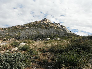
Little peak with a big view by azbackpackr  Parking is not at the trailhead, but is in the day use area of Paso Picacho, across the highway from the trailhead. There is also a campground here. There is a day use fee per vehicle. Check fees near directions for the current rate. After visiting the self-pay booth and parking at the picnic area, walk back across the highway to the trailhead, easily visible.
Although the park has the Southern California version of a four-season climate, with occasional heavy snow in winter, the snow does not last long, and the hiking season is generally year-round. Cross country skiing and snowshoeing are possible, very occasionally. The trail to Stonewall Peak is very straightforward, switch-backing up the slope until it gets to a T-junction at the top of a ridge. Turn right here and a short distance later make your way over boulders to the rock steps leading to the summit rock which has a railing around it. Informational placards are also placed here to orient the hiker to vistas in the four directions. If you had turned left at the T-junction, you'd head back down the mountain on a different trail to the north. You could then connect with the Cold Stream Trail, and loop back south to the parking lot. Doing this loop would add an extra mile to the total distance hiked. Maps: 1. A very superior trail map is available from Tom Harrison Maps. 2. USGS 7.5 minute topographic map: Cuyamaca Peak. 3. Park brochure map, available online. More information about the park can be obtained at http://www.parks.ca.gov/?page_id=667 or by calling the park at (760)735-3020. Check out the Official Route and Triplogs. Leave No Trace and +Add a Triplog after your hike to support this local community. One-Way Notice This hike is listed as One-Way. When hiking several trails on a single "hike", log it with a generic name that describes the hike. Then link the trails traveled, check out the example. | |||||||||||||||||||||||||||||||||||||||||||||||||||||||||||||||||||||||||||||||||||||


