Route Editor

| Guide | ♦ | 13 Triplogs | 0 Topics |
details | drive | no permit | forecast | 🔥 route |
stats |
photos | triplogs | topics | location |
| 182 | 13 | 0 |
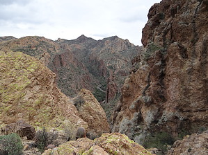
North of Little Four Peaks by twynn479  Overview OverviewThis hike follows the ridgeline that separates HWY 88 (Apache Trail) and First Water Creek as it drains into Canyon Lake. My objective was to reach each descending highpoint along the ridgeline. I counted 8 individual peaks/overlooks—see how many you can find. You can hike this trail as an out-and-back or easy shuttle-hike. I like to hike this trail (and it isn’t an official forest trail, but a route that is well-cairned) all the way through by starting at Apache Gap Trailhead (no sign). It is the pullout on the northwest side of the highway at mile marker 205.3, and finishing up at a pullout on HWY 88 at mile marker 207.4 right next to a metal transmission tower with the number 174 on it. Getting Started Park on the northwest side, cross over the highway and head through the fence going south up on an old 4x4 road. In about 200 yards the road will go to the right, but you want to go straight. You will see cairns from here, follow them until you reach the first creek crossing (by the way this is Willow Creek you are hiking up). The route will fork here, you can go straight up the drainage to a popular hike to Peak 2980 and the Little Four Peaks, but for this hike, you will head north towards Canyon Lake. Look for the cairns on the left, they will take you up a steep hill to a saddle— to your first overlook.
When you top out on the first peak, you will see Peak 2980 to the southwest and Canyon Lake to the north. This will be your first overlook and the highest elevation of the hike. From here, you will be losing elevation moving towards Canyon Lake (although you will be climbing up to each overlook, follow the cairns they will lead you to each descending overlook). The 7th one is very close to the creek and has a very narrow and steep grade to the top— so be careful when you reach the top, but no worries there is nothing technical on this hike, just some great views and a fun trail that will give you a good workout for a short day hike close to town. If you are hiking this route as an out-and-back you can do a loop back to the main trail: hike toward the highway, the creek will force you north back to HWY 88. Look for a faint trail on your left that will lead back to the southwest direction and up to 2 more overlooks. Here you will have an idea of where you have come from and you can follow the cairns back to the main trail and onto Apache Gap, or retrace your steps back to HWY 88 and the metal transmission tower (where your shuttle car is parked). Note I would classify it as off-trail, but there is a well-defined path with no bushwhacking and only one cactus forest to negotiate, but there are a few fun rock scrambles that anyone of any age or condition can manage (adds to the fun I think). And it would be a good first-timer off-trail hike because you will be forced to follow the ridgeline and the overlooks will give you an idea of the terrain you are traversing. Have fun. Check out the Official Route and Triplogs. Leave No Trace and +Add a Triplog after your hike to support this local community. | |||||||||||||||||||||||||||||||||||||||||||||||||||||||||||||||||||||||||||||||||||||||||||||||||||