 Route Editor

| Guide | ♦ | 58 Triplogs | 0 Topics |
details | drive | no permit | forecast | map |
stats |
photos | triplogs | topics | location |
| 288 | 58 | 0 |
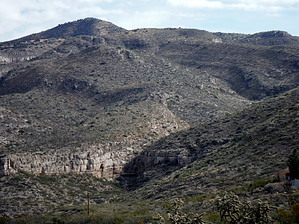
It's a Handy Connection... by imike Folks tend to drive over and park at four or five key intersections that allow for easy access to the trails and routes.
This broken route is the path left from the excavation of the trench for the city's main waterline to all of the water tanks positioned above the town. It begins on the far south at the Alamo Canyon Trailhead (T104)... running from Alamo Canyon Road north along the base of the foothills. At times it is an obvious wide roadbed... At times it seems to disappear... For most of the distance it is on National Forest land... It is just an alley behind a housing development for some of the miles... Towards its far north end it is buried under a road (Scenic Drive)... but that makes for very easy walking; there's a sidewalk! It's final stretch can be found running north starting behind the Community Church on Scenic Drive... It terminates at the Water tank near Beeman Canyon. Starting on the south end it provides access (to name just a few) to Prominent Point, Dome Rock, Quiet Canyon, Goat Springs Trail, Marble Canyon, "A" Trail, Terri's Cut, Ortega Canyons, Lost Trail Canyons, Mineral Springs Canyons, Indian Wells, The Garden Wall, Beeman Canyons... and if you add in a bit of old roadbed on the north, it carries you all the way around to Dry Canyon. Typical interim connections: Foothills Mountain Park, 10th Street Firestation, Thunder Road, Indian Wells at Scenic Drive, The Community Church on Scenic... The entire length makes for a nice in town mountain bike route... If you like to add some extra miles on to any of the local hikes, enjoy the easy walking Pipeline Road! Check out the Triplogs. Leave No Trace and +Add a Triplog after your hike to support this local community. One-Way Notice This hike is listed as One-Way. When hiking several trails on a single "hike", log it with a generic name that describes the hike. Then link the trails traveled, check out the example. | ||||||||||||||||||||||||||||||||||||||||||||||||||||||||||||||||||||||||||||||||||||||||||||||||||||||||||||||||||||||||||||||||||||||||||||||||||||||||||||||||||||||||||||||||||||||


