Route Editor

| Guide | ♦ | 8 Triplogs | 0 Topics |
details | drive | no permit | forecast | map |
stats |
photos | triplogs | topics | location |
| 103 | 8 | 0 |
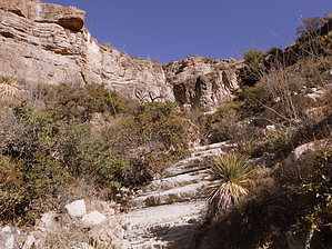
Canyons are inherently risky. Flash floods occur without notice on sunny days. Technical skills & surrounding topography knowledge required yet does not eliminate risk.
Steep... Really Steep!! by imike  Different than the other area cuts, this one could nearly be classified as a Hike... but not quite. There is some very low level scrambling, but for the most part, you walk. You walk up. You walk up, steeply!
You will enjoy climbing this slanted bedrock slab, stopping to take in the ever changing views. Once to the Falls, you have a variety of options: Head up towards the tree growing to your right... it hides a cleft that makes for an easy ascent of the Falls. Once on top of the Falls you can follow the broader, slightly overgrown, upper canyon to connect with the "A" Trail at 7138'. At that point, if you are parked at the Firestation, you will have logged close to 3.3 miles. Might as well round out your day by hitting Ortega Peak! Or, from the top of the Falls, head north- across and down to connect with N3, Ridge Canyon, for a fun and easier descent back around to Marble Canyon North. Or, from the top of the Falls, head north- across and up to connect with the "A" Trail at the top of N1, Grotto Canyon. Or, climb back down off the Falls and enjoy the walk back the way you came... However you decide to conclude your day, this canyon ascent makes sure you'll enjoy a great day out. Note: N4, Slab Canyon, is accessed by hiking up Marble Canyon North, passing Marble Bluff and the first side canyon to your left, Marble Canyon North Spur (N2)... proceeding on to the next major cut to your left. You will be 1.8 miles from your car back at the Firestation/City Park. Check out the Triplogs. Leave No Trace and +Add a Triplog after your canyon trip to support this local community. | ||||||||||||||||||||||||||||||||||||||||||||||||||||||||||||||||||||||||||||||||||||||||