 Route Editor

| Guide | ♦ | 3 Triplogs | 1 Topic |
details | drive | no permit | forecast | map |
stats |
photos | triplogs | topic | location |
| 40 | 3 | 1 |
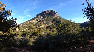
  A prominent butte that rises 2000 feet above the Verde River, just south of the confluence of the East Verde. Off-trail access is easiest from FR16 to the saddle southwest of the butte, then directly up the very steep slope to the peak. A prominent butte that rises 2000 feet above the Verde River, just south of the confluence of the East Verde. Off-trail access is easiest from FR16 to the saddle southwest of the butte, then directly up the very steep slope to the peak.Check out the Triplogs. Leave No Trace and +Add a Triplog after your hike to support this local community. One-Way Notice This hike is listed as One-Way. When hiking several trails on a single "hike", log it with a generic name that describes the hike. Then link the trails traveled, check out the example. | ||||||||||||||||||||||||||||||||||||||||||||||||||||||||||||||||||||||||||||||||


