username
X
password
register
for free!
help


Long Peak - Mazatzal/Verde, AZ

Guide 2 Triplogs  0 Topics
  4.5 of 5  
Fav
Wish
1
details
drive
no permit
forecast
map
stats
photos
triplogs
topics
location
0 2 0
Statistics
tap row or icons for details
Difficulty 1.5 of 5
Distance One Way 1 mile
Trailhead Elevation 4,820 feet
Elevation Gain 335 feet
Accumulated Gain 450 feet
Kokopelli Seeds 2.5
 Interest Off-Trail Hiking & Peak
feature photo
Photos Viewed All MineFollowing
53  2022-03-28
Long Benchmark with Views
FLYING_FLIVER
28  2014-01-04
Long way to Squaw
chumley
Author
author avatar Guides 16,843
Routes 17,472
Photos 24
Trips 1 map ( 6 miles )
Age 28 Male Gender
Location HAZ, TrailDEX
Associated Areas
list map done
Camp Verde Region
Historical Weather
Trailhead Forecast
Expand Map
Preferred Apr, Oct, Mar, Nov
Sun  6:03am - 6:48pm
0 Route
 
2 Alternative


remove free decal offer

  
Guide Needed
Publish Full Detail Guide


Use +Add above to share photos and triplogs
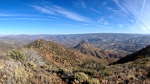
The high point on the ridge between Long Mesa and the Verde River on the far northwestern boundary of the Mazatzal Wilderness.


    Check out the Triplogs.
    Leave No Trace and +Add a Triplog after your hike to support this local community.

    One-Way Notice
    This hike is listed as One-Way.

    When hiking several trails on a single "hike", log it with a generic name that describes the hike. Then link the trails traveled, check out the example.
    WARNING! Hiking and outdoor related sports can be dangerous. Be responsible and prepare for the trip. Study the area you are entering and plan accordingly. Dress for the current and unexpected weather changes. Take plenty of water. Never go alone. Make an itinerary with your plan(s), route(s), destination(s) and expected return time. Give your itinerary to trusted family and/or friends.

     Permit $$
    None


     Directions
    or
     Road
    High Clearance possible when dry

    To hike
    From Phoenix, take Cave Creek road north (FR24) to Bloody Basin Road. From there, take FR16 north about 19 miles to edge of Long Mesa and start of hike.
    page created by chumley on Jan 05 2014 1:07 am
     90+° 8am - 6pm kills
    helpcorrectionissue

    end of page marker