 Route Editor

| Guide | ♦ | 12 Triplogs | 1 Topic |
details | drive | permit | forecast | 🔥 route |
stats |
photos | triplogs | topic | location |
| 164 | 12 | 1 |
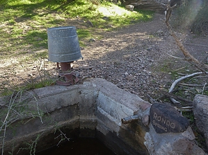
Help me Rondo yeah, get this hike off a my chart! by AZWanderingBear  Overview OverviewThere is a seldom-used trail along the north side of the Elephant that intersects with the Spur Cross trail system from the West. Ranchers have used the trail for a long time to access Rondo Spring. Access East Cavalry Road in New River ends at a gate (N 33 52.737 W 112 01.818) which opens into AZ State Trust Land and an active ranching operation. The hike can begin here, or if you have a 4X4 with some good clearance and a sufficient sense of adventure (and the required State Trust Land permit), you may drive the first bit of the trail since it uses some of the old ranch roads. Be sure to close the gate either way.
The hike follows existing ranch roads for the first two miles. The roads end just beyond Upper Well, easily identified south of the trail. A single-track trail proceeds another two miles to Rondo Spring. The trail will go through a gate approximately 0.6 miles after becoming a single-track trail. From there, you will descend into a wash. You will occasionally climb out of the wash to rejoin it later, so watch for cairns. Rondo Spring is approximately four miles into the hike. A hand pump is available to pump water. A large bucket hangs over the pump to prime the pump from the water in the stock tank. Ranchers and equestrians use this tank to water their stock. The Rondo Spring oasis shows the results of many decades of usefulness. Take time to explore the area. Every time I have been to Rondo Spring, a game camera is mounted on the large tree to the south of the tank. Smile! Turn North at the Spring for a short climb up to a trail intersection creatively marked with a rock turtle. North takes you up the Skull Mesa Trail. East leads into the Spur Cross trail system. Look South for a nice view of the Elephant. This trail is not actively maintained to my knowledge. It is rugged with loose rock in many places. The largest rattlesnake I ever encountered was along this trail some years ago. While close to populated areas, this is truly Arizona backcountry. Take the appropriate precautions. Gate Policy: If a gate is closed upon arrival, leave it closed after you go through. If it is open, leave it open. Leaving a closed gate open may put cattle in danger. Closing an open gate may cut them off from water. Please be respectful, leave gates as found. The exception is signage on the gate directing you otherwise. Check out the Official Route and Triplogs. Leave No Trace and +Add a Triplog after your hike to support this local community. One-Way Notice This hike is listed as One-Way. When hiking several trails on a single "hike", log it with a generic name that describes the hike. Then link the trails traveled, check out the example. | |||||||||||||||||||||||||||||||||||||||||||||||||||||||||||||||||||||||||||||||||||||||||||||||||||||||||||||||||||||||||||||||||||||||||||||||||||||||||||||||||||||||||||||||||||||||||||||


