Route Editor

| Guide | 0 Triplogs | 0 Topics |
details | drive | permit | forecast | route |
stats |
photos | triplogs | topics | location |
| 27 | 0 | 0 |
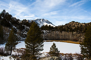
forward past the tarns by slegal Parking is off road as there is no parking allowed on Northshore Rd. If there is no parking near the trailhead (unlikely), consider parking at the baseball field at the corner of Northshore Dr. and Mountain Vista Dr. It’s a short walk south on Northshore Dr. to the trailhead.
As the trail reaches a saddle at the top of the hill the first tarn will come into view. The trail travels along the east side of the tarns. I generally go off trail and visit one or two of the tarns and then turn around at this point. However, the trail does continue on past these tarns and past several large junipers before reaching a flat brushy section. To the right is a hill and the trail wraps around the far side of this hill before heading down a ravine toward the baseball field described earlier. Check out the Official Route. Leave No Trace and +Add a Triplog after your hike to support this local community. | |||||||||||||||||||||||||||||||||||||||||||||||||||||||||||||||||||||||||||||||||||