Route Editor

| Guide | ♦ | 10 Triplogs | 1 Topic |
details | drive | permit | forecast | route |
stats |
photos | triplogs | topic | location |
| 150 | 10 | 1 |
The Writing Is On The Wall by AZLOT69   2022-01-06 2022-01-06The Official Route was updated with an option to hike around the [ private ] [ property ]. Probably a bit errie but it is seemingly the shortest legal option. 2013-12-12 Vehicles are no longer allowed to drive down the wash. There is a signposted by the Bureau of Land Management preventing vehicles from driving very close. The sites are now also marked as an "archeological" area. In addition, the cabin has now collapsed into a pile. The petroglyphs remain a fantastic find for hikers. ( correction #2708 from Jerry W. )
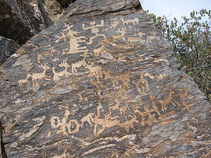
This hike takes place in an area rich with historical significance to Arizona. Considered prehistoric people, some of the earliest residents, the Hohokam Indians, lived here. They were desert dwellers who could capitalize on the few water resources available and survive for hundreds of years by irrigating and farming. The core area of their habitation was the Gila-Salt river basin which includes the entire Valley of the Sun. The Hohokam disappeared in about 1450, leaving little written record of their experience. Perhaps that is why we cherish the petroglyphs and attempt to interpret them. These petroglyphs are typical Hohokam with images of spirals, lizards, animals, and human figures. One human figure at this site appears to be giving birth. Following the Hohokam were the Spanish, the Mexicans, and eventually the Anglo people, most of whom sought fortune. This area, now known as the Mineral Mountain Mining District, is mentioned in many Lost Dutchman and the Peralta Treasures stories. There are several ghost towns in the area and several active, working mining claims. While protected and managed by the BLM, the twenty-first-century recreational lifestyle is encroaching and literally at the heels of this historic site. Access to the site involves traveling across State Land Trust, which the military uses several times of the year for war games and live artillery fire. Caution should be used if red flags are posted. Read the warning signs for posted dates of military activity. ATVs and motorcycles heavily use the State Trust Land on the weekends. The hike itself is shared at times by extreme rock crawling vehicles that pass within feet of the petroglyphs. Hike The hike starts where Cottonwood Canyon Road Meets the Cottonwood Canyon Wash. While there is no formal trailhead here, there is ample parking in the wash. This starting spot is accessible by two-wheel drive vehicles. Four-wheel drive with high clearance can go an additional half mile to the formal trailhead where there is parking for only one car. I suggest hike it and get a feel for the area. An old settlement marks the beginning of the hike. A building sliding off its foundation and the adjoining well make for some nice pictures. A large neighboring stone foundation with steps leading up to it will leave you curious about its origin and use. Continue east in the wash/canyon. At 0.32 miles, the road leaves the wash to the right going up to the formal trailhead at the top of the hill. If you are hiking, bear left in the wash and continue east. Watch among the gray rock for varnished brown rocks lining the canyon for petroglyphs. At a little over two-thirds of a mile, the canyon starts to narrow and choke with boulders. The brown varnished rocks lining the canyon abound with petroglyphs. Continue east in the canyon, being ever alert for more writing. At 0.93 miles, the wash rejoins the road. Turn right and follow the road up the hill to the formal trailhead. Take the trail back down to the wash. There are several placards along the trail. Once in the wash, you can enjoy the petroglyphs once again and then head west back to your vehicle.
Check out the Official Route and Triplogs. Leave No Trace and +Add a Triplog after your hike to support this local community. | ||||||||||||||||||||||||||||||||||||||||||||||||||||||||||||||||||||||||||||||||||||||||