 Route Editor

| Guide | ♦ | 1 Triplog | 0 Topics |
details | drive | no permit | forecast | route |
stats |
photos | triplog | topics | location |
| 136 | 1 | 0 |
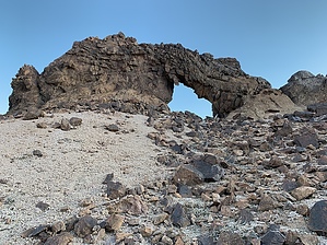
spectacular views by lanceware This destination is located in the Indian Pass Wilderness Area in southeastern California. There is no marked trail, but the route is mostly in a wash which is easy to follow. There are three rock arches located in close proximity to each other. The largest is about 8 feet high. Another is about 3 feet. The third is maybe 5 feet high. The views of the mountain ranges along the way and at the arches is spectacular. Hike After taking the dirt road to the parking area, continue further down the road on foot. After about 0.75 miles, there will be an iron barricade on the left. Turn here, leaving the road, and enter a wash (Gavilan Wash). Follow the wash northwest for about 1.5 miles. The wash is easy to navigate and generally fairly clear of boulders and bushes. When the wash makes a sharp right turn, continue following it into an area with whitish/yellowish rock mixed with dark volcanic rock. Look up and ahead towards the right and you should soon see at least one of the arches. Watch for a large cairn on the right side of the wash, and take the somewhat faint trail upwards to the first two arches. The third arch is further up above the other two. Some scrambling over loose rock is required, but it is not that difficult. Check out the Official Route and Triplog. Leave No Trace and +Add a Triplog after your hike to support this local community. One-Way Notice This hike is listed as One-Way. When hiking several trails on a single "hike", log it with a generic name that describes the hike. Then link the trails traveled, check out the example. | |||||||||||||||||||||||||||||||||||||||||||||||||||||||||||||||||||||||||||||||||||||||||||||||


