username
X
password
register
for free!
help
 
  🔥

Gila River Canyons - AZT #16, AZ

Guide 115 Triplogs  11 Topics
  4.3 of 5  
Fav
Wish
5
details
drive
no permit
forecast
🔥
route  
stats
photos
triplogs
topics
location
1.7k 115 11
Statistics
tap row or icons for details
Difficulty 4.5 of 5
Distance One Way 24.67 miles
Trailhead Elevation 1,798 feet
Elevation Gain 1,903 feet
Accumulated Gain 4,850 feet
Kokopelli Seeds 40.83
 Interest Seasonal Creek
unreported if dogs are allowed
editedit > ops > dogs to adjust
feature photo
Photos Viewed All MineFollowing
Will recalculate on button tap!
26  2023-03-04 DarthStiller
27  2023-03-04 adilling
22  2022-03-18 kyleGChiker
6  2021-04-05 robxxx
7  2021-03-10 Sredfield
41  2020-01-31 ultrazona
3  2019-05-10
Alamo Canyon - AZT #17
toddak
4  2018-11-02 ttretta
Page 1,  2,  3,  4,  5 ... 10
Author
author avatar Guides 16,843
Routes 17,472
Photos 24
Trips 1 map ( 6 miles )
Age 28 Male Gender
Location HAZ, TrailDEX
Associated Areas
list map done
Globe Region
Historical Weather
Trailhead Forecast
Radar Map
Expand Map
Preferred Dec, Jan, Feb, Mar → 7 AM
Sun  6:00am - 6:45pm
Official Route & 21 Rts
 
9 Alternative
 
Historic Fire Perimeteracres
🔥 2021 Telegraph Fire266.7 mi**


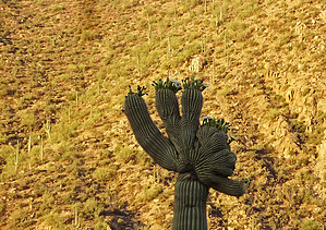
Knock it out Cry Baby
by HAZ_Hikebot

 
Overview
This passage begins at the Kelvin Bridge as it crosses the Gila River. Just beyond the north end of the bridge the route turns west onto Centurian Road and follows this through a private home area to the new single-track trail. The trail then follows the Gila River for many miles - sometimes rising several hundred feet above and sometimes near river level. It passes through several gates, crosses numerous canyon drainages, and occasionally catches a glimpse of The Spine, Walnut Canyon Narrows, Copper Butte, and The Rincon, all to the north.


At just over 15 miles from the beginning, the trail turns north, leaving the river, and traverses through the canyons. It climbs steadily on new single-track and several short sections of old mining roads. After traversing spectacular ridgelines and winding around numerous side drainages, the trail crosses the boundary of Tonto National Forest and then ends at a gate on an abandoned two-track road.
remove free decal offer
Southern Trailhead: Gila River - Kelvin Bridge

Northern Trailhead: Tonto NF Boundary

Note
This page is open to authors. The hike must be listed South to North as one-way. Do not include an overview as the above is permanent.

Gate Policy: If a gate is closed upon arrival, leave it closed after you go through. If it is open, leave it open. Leaving a closed gate open may put cattle in danger. Closing an open gate may cut them off from water. Please be respectful, leave gates as found. The exception is signage on the gate directing you otherwise.

2018-07-14 HAZ_Hikebot


    Check out the Official Route and Triplogs.

    Note
    This is a more difficult hike. It would be unwise to attempt this without prior experience hiking.
    Leave No Trace and +Add a Triplog after your hike to support this local community.

    One-Way Notice
    This hike is listed as One-Way.

    When hiking several trails on a single "hike", log it with a generic name that describes the hike. Then link the trails traveled, check out the example.
    WARNING! Hiking and outdoor related sports can be dangerous. Be responsible and prepare for the trip. Study the area you are entering and plan accordingly. Dress for the current and unexpected weather changes. Take plenty of water. Never go alone. Make an itinerary with your plan(s), route(s), destination(s) and expected return time. Give your itinerary to trusted family and/or friends.

     Permit $$
    None


     Directions
    or
     Road
    FR / Jeep Road - Car possible when dry

    To hike
    From the PHOENIX AREA: Take Hwy 60 to Superior; In Superior take Hwy 177 south for ~15.5mls to MP 152.2; Just before crossing Railroad Tracks turn Right on to Kelvin/Florence Highway and continue for 1.2mls; Just before crossing the Gila River/Bridge, turn Right on unsigned dirt road- East Centurian Lane(not signed as of this posting); Continue driving on this dirt/gravel road for approx .33mls to the "first house" on right side of road; Continue to "just past" the front of this house and note not signed dirt/gravel road to your left; "Do not" pass this house but instead turn LEFT on this not signed dirt road and continue ~straight for approx an additional ~.33mls to the AZT TH Parking on Right side of road(there is no AZT TH Post/Marker as of this writing only a cairn and orange marker tape denoting the AZT trail start); NOTE: As you drive in this above noted last ~.33mls to the TH start, do not take sharp left turn spur dirt road and do not take the next right turn spur road, but continue ~straight on this .33ml drive to the TH and small parking area on right side of road;
    page created by Grasshopper on Dec 13 2008 11:31 pm
     90+° 8am - 6pm kills
    helpcorrectionissue

    end of page marker