Route Editor

| Guide | ♦ | 3 Triplogs | 0 Topics |
details | drive | no permit | forecast | route |
stats |
photos | triplogs | topics | location |
| 38 | 3 | 0 |
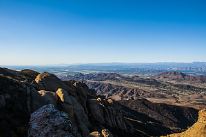
 A little history is worthwhile here. At the north end of the Old Cabin Trail is the old cabin site. The cabin was a hunting cabin owned by the Danielson family. The Danielson family owned Danielson Ranch which is the majority of the land that makes up Point Mugu State Park and Rancho Sierra Vista National Park. They lived in the ranch house that is half way down Sycamore Canyon road between Newbury Park and Sycamore Beach. The ranch house is now the park headquarters.
There are three main ways to get to the Old Cabin Trail. Two of them are from Newbury Park and the third is from Circle X Ranch. If you are able to park at Circle X Ranch and Take either the Mishe Mokwa Trail or the Backbone Trail to the Tri Peaks Trail and then to the Old Cabin Trail, and then hike down the Old Cabin Trail to the old cabin site and back, then you are either crazy, super human or both. Most people either park at the National Park parking lot and take the Sycamore Canyon Trail to Danielson Road to the Old Cabin Trail or park at the Wendy trailhead and take the Wendy Trail to the left fork of the Wendy Trail, to Danielson Road to the Old Cabin Trail. The Old Cabin Trail is not a maintained trail. It’s also not a well-planned trail. Consequently, it suffers from serious erosion. One section of the trail has an erosion rut that is about 8 feet deep. There are many steep sections of the trail that require a considerable amount of scrambling because of all of the topsoil that has eroded away over the years. What the Old Cabin Trail lacks in planning and maintenance it more than makes up for in views. The higher you get, the better the views of the ocean and Channel Islands, the Topa Topa Mountains and the San Gabriel Mountains becomes. You also climb to the base of Trip Peaks, which I believe is the second highest point in the Santa Monica Mountains. From the Wendy trailhead to the base of Tri Peaks is approximately 10 miles. Check out the Official Route and Triplogs. Note This is a more difficult hike. It would be unwise to attempt this without prior experience hiking. Leave No Trace and +Add a Triplog after your hike to support this local community. | ||||||||||||||||||||||||||||||||||||||||||||||||||||||||||||||||||||||||||||||||||