Route Editor

| Guide | ♦ | 49 Triplogs | 0 Topics |
details | drive | no permit | forecast | route |
stats |
photos | triplogs | topics | location |
| 433 | 49 | 0 |
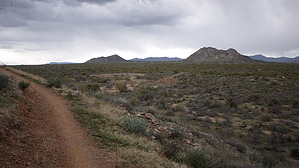
Fraesfield Mountain meander by Crzy4AZ  This day hike loop in the northern section of the McDowell Sonoran Preserve combines three trail segments originating from the new (2013) Fraesfield Trailhead: Whiskey Bottle Trail (1.6 miles), Turpentine Trail (1.4 miles), and Black Hill Trail (1.7 miles). The loop described hugs the northeastern edge of Fraesfield Mountain ( name origin is undiscovered[1] ) and then winds through the washes and basins south of Granite Mountain. This day hike loop in the northern section of the McDowell Sonoran Preserve combines three trail segments originating from the new (2013) Fraesfield Trailhead: Whiskey Bottle Trail (1.6 miles), Turpentine Trail (1.4 miles), and Black Hill Trail (1.7 miles). The loop described hugs the northeastern edge of Fraesfield Mountain ( name origin is undiscovered[1] ) and then winds through the washes and basins south of Granite Mountain.From the parking lot take Black Hill Trail 0.1 mile and head northwest on Whiskey Bottle Trail 1.5 miles with the only slight elevation gain of this loop. The trail in this section is firmly packed but narrow and offers 180-degree panoramic views of Tom’s Thumb ridgeline, Four Peaks, and the Mazatzals. There is no access to the peak of Fraesfield Mountain (3,055 elevation) which is on private land and not part of the Preserve. After you cross the intersection with Dixileta Trail continue another 0.1 miles to trail marker WB3 and head northeast on Turpentine Trail.
This loop is an ideal late afternoon sunset hike and you might extend your distance by connecting to the other loops around Granite Mountain . Mountain bikers, trail runners, and hikers will enjoy this undeveloped section of the Preserve. Just remember to bring water as there is none at the trailhead (and no bathrooms either).
Check out the Official Route and Triplogs. Leave No Trace and +Add a Triplog after your hike to support this local community. | |||||||||||||||||||||||||||||||||||||||||||||||||||||||||||||||||||||||||||||||||||||||||||||||||||||||||||||||||||||||||||||||||||||||||||||||||||||||||||||||||||||||||||||||||