username
X
password
register
for free!
help
 This is likely a great time to hike this trail!  Check out "Preferred" months below, keep in mind this is an estimate.
  

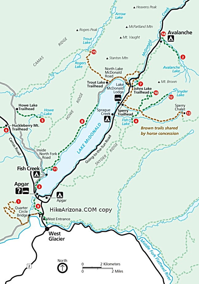
Beaver Pond Loop GNP, MT

Guide 6 Triplogs  0 Topics
  3 of 5  
Fav
Wish
0
details
drive
permit
forecast
route  
stats
photos
triplogs
topics
location
169 6 0
Statistics
tap row or icons for details
Difficulty 0.5 of 5
Distance Round Trip 3.44 miles
Trailhead Elevation 4,533 feet
Elevation Gain 280 feet
Accumulated Gain 318 feet
Kokopelli Seeds 5.03
 Dogs not allowed
Photos Viewed All MineFollowing
Inaugural Calculation on Button Tap!
41  2023-07-10 tibber
29  2022-07-18 tibber
18  2022-06-08
Beaver Dam Loop
markthurman53
29  2021-08-07 tibber
52  2013-07-09 tibber
Author
author avatar Guides 16,843
Routes 17,472
Photos 24
Trips 1 map ( 6 miles )
Age 28 Male Gender
Location HAZ, TrailDEX
Associated Areas
list map done
North Central Region
Historical Weather
Trailhead Forecast
Radar Map
Expand Map
Preferred Sep, Jun, May, Jul
Sun  5:56am - 7:08pm
Official Route & 3 Rts
 
1 Alternative


remove free decal offer

 Likely In-Season!
Guide Needed
Publish Full Detail Guide


Use +Add above to share photos and triplogs
start from 1913 Old St Mary Ranger Station, hike thru forest and then the rest is in and out of meadows and aspen grove as you make your way toward and along St Mary Lake.


  • goat haunt map st mary map mcdonald map
    area related


Check out the Official Route and Triplogs.
Leave No Trace and +Add a Triplog after your hike to support this local community.
WARNING! Hiking and outdoor related sports can be dangerous. Be responsible and prepare for the trip. Study the area you are entering and plan accordingly. Dress for the current and unexpected weather changes. Take plenty of water. Never go alone. Make an itinerary with your plan(s), route(s), destination(s) and expected return time. Give your itinerary to trusted family and/or friends.

 Permit $$
None

Glacier National Park
$30 per car(week), $12 bike/foot(week), $50 annual View Current Entrance Fees


 Directions
or
 Road
FR / Dirt Road / Gravel - Car Okay

To hike
from the town of St Mary: turn left towards the Historic 1913 Ranger Station/Red Eagle Lake Trailhead, (between the Glacier National Park entrance sign and the St Mary Entrance Station). Drive for about .2 miles, veer right and continue straight on the gravel road leading towards the parking area.
page created by tibber on Feb 03 2014 11:33 am
 90+° 8am - 6pm kills
helpcorrectionissue

end of page marker