Route Editor

| Guide | ♦ | 7 Triplogs | 0 Topics |
details | drive | permit | forecast | map |
stats |
photos | triplogs | topics | location |
| 107 | 7 | 0 |
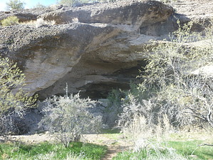
Where's the Cave in Cave Creek by AZWanderingBear  History HistorySo how do places in Arizona get their names? We all know about Cave Creek, the city, and Cave Creek, the creek. Is there a real cave? Yes, Virginia, there is a cave in Cave Creek along Cave Creek. While you may not have known that fact, the residents of Cave Creek dating back to pre-Hohokam days did. The cave has been inhabited off and on for millennia. One inhabitant in the later 19th Century was oddly enough a sometimes prospector named Ed Cave. Overview This hike is a very short easy stroll along the lower portion of Cave Creek to the cave. Residents seem to take their horses along the creek fairly often. But the cave is located on private property, so you will need permission.
Hikes to the Cave are organized by the Desert Foothills Land Trust. Check their website for schedules. Hikes are guided and free. Due to the sensitivity of the cave, no other information regarding location or routing is provided here. Hike The hike is relatively flat along Cave Creek. You pass through a Sonoran riparian area with mesquites, various cacti including some impressive saguaros. During any wet times of the year, Cave Creek may have water in it this far south. The cave is an erosional cave and no specific equipment or lighting is required. Inside the cave are both Hohokam petroglyphs and Yavapai pictographs as well as more modern graffiti from the 1800s to the present. Check out the Triplogs. Leave No Trace and +Add a Triplog after your hike to support this local community. | ||||||||||||||||||||||||||||||||||||||||||||||||||||||||||||||||||||||||||||||||||||||