Route Editor

| Guide | ♦ | 176 Triplogs | 0 Topics |
details | drive | no permit | forecast | route |
stats |
photos | triplogs | topics | location |
| 2.2k | 176 | 0 |
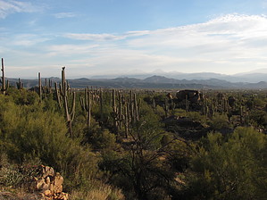
a solid loop by DarthStiller   The Granite Mountain Loop Trail, as its name indicates, is a 4.2-mile loop around Granite Mountain in the McDowell Sonoran Preserve. The easiest access to this trail is from the Granite Mountain Trailhead, but it can also be easily reached from the Fraesfield Trailhead via the Black Hill Trail. The very short 0.2 mile Granite Mountain Trail serves as the primary connector and starting point of the loop, and this description will start from that junction with the loop trail at the southern end of the loop. The Granite Mountain Loop Trail, as its name indicates, is a 4.2-mile loop around Granite Mountain in the McDowell Sonoran Preserve. The easiest access to this trail is from the Granite Mountain Trailhead, but it can also be easily reached from the Fraesfield Trailhead via the Black Hill Trail. The very short 0.2 mile Granite Mountain Trail serves as the primary connector and starting point of the loop, and this description will start from that junction with the loop trail at the southern end of the loop.The trail is a newly constructed and single track. The vegetation at the start is fairly dense with many Palo Verdes, teddy bear and buckhorn chollas, and a saguaro forest on the south and east sides of the mountain. There are also several granite boulders strewn about that adds to the more proximate scenery. The trail does a quick and mild ascent and the levels out soon. The views to the east of Four Peaks and Mt. Ord and the Mazatzals further north are nice, although in the morning it’s hard to see with the sun behind them. Below you in front of the mountains, views into the development and ranches can be seen. Along this section are junctions with the Saddlehorn and Bootlegger’s Trails, which can take you back to the Granite Mountain Trailhead on the eastern end of the preserve, or connecting to other trails for other loops.
Turning left at this junction and heading west across the north face of the mountain, the trail begins to descend and the vegetation thins out somewhat. Views to the north include the Cave Creek area and the western end of the newly expanded preserve area. As you turn south, the powerlines become a prominent feature as well as the McDowell Mountains again. To your left, Granite Mountain also becomes a more prominent feature as this side of it is steeper and higher, compared to the more gentle slopes on the east side. If you’re hiking in the morning, this will also provide some shade. At the junction of the Balanced Rock Trail, turn left again and make it back to the starting point, checking out the views to the east again.
Check out the Official Route and Triplogs. Leave No Trace and +Add a Triplog after your hike to support this local community. | ||||||||||||||||||||||||||||||||||||||||||||||||||||||||||||||||||||||||||||||||||||||||||||||||||||||||||||||||||||||||||||||||||||||||||||||||||||||||||||||||||||||||||||||