username
X
password
register
for free!
help


Torrey Pines State Beach S & Natural Reserve, CA

Guide 10 Triplogs  0 Topics
  3.8 of 5  
Fav
Wish
0
details
drive
permit
forecast
map
stats
photos
triplogs
topics
location
64 10 0
Statistics
tap row or icons for details
Difficulty 1.5 of 5
Distance Round Trip 2.5 miles
Trailhead Elevation 15 feet
Elevation Gain 250 feet
Accumulated Gain 350 feet
Kokopelli Seeds 4.25
 Dogs not allowed
feature photo
Photos Viewed All MineFollowing
4  2023-08-18 toddak
12  2021-07-19 The_Dude
27  2020-11-14 azbackpackr
3  2017-01-31 fricknaley
18  2015-10-11 DarthStiller
Author
author avatar Guides 16,843
Routes 17,472
Photos 24
Trips 1 map ( 6 miles )
Age 28 Male Gender
Location HAZ, TrailDEX
Associated Areas
list map done
San Diego Region
Historical Weather
Trailhead Forecast
Expand Map
Preferred Nov, Apr, May, Jan
Sun  5:26am - 6:09pm
6 Routes
 
0 Alternative


Torrey Pines State Beach (SOUTH) and Natural Reserve


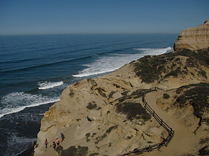
From the South Beach and Reserve Entrance at the foot of the hill on North Torrey Pines Road, you can access parking (for a fee) and multiple trails including:


1.Guy Fleming Trail – 0.7 mile loop.
remove free decal offer
2.Parry Grove Trail – 0.5 mile loop.

3.Razor Point Trail – 0.7 mile to point. HAZ has Razor Trail listed => https://hikearizona.com/decoder.php?ZTN=14126

4.Broken Hill Trail - Access to beach via north fork is 1.2 miles or via south fork is 1.3 miles.

5.Beach Trail- 0.75 miles to Flat Rock and beach.


NOTE: Razor Point - Yucca Point - Beach Trail Loop, CA already listed on HAZ.


See www.torreypine.org for more information about Torrey Pines State Beach and Natural Preserve…

2018-07-14 HAZ_Hikebot
  • Torrey PDF Page 1
    guide related
    Torrey PDF Page 1
  • Torrey PDF Page 2
    guide related
    Torrey PDF Page 2


Check out the Triplogs.
Leave No Trace and +Add a Triplog after your hike to support this local community.
WARNING! Hiking and outdoor related sports can be dangerous. Be responsible and prepare for the trip. Study the area you are entering and plan accordingly. Dress for the current and unexpected weather changes. Take plenty of water. Never go alone. Make an itinerary with your plan(s), route(s), destination(s) and expected return time. Give your itinerary to trusted family and/or friends.

 Permit $$
CA State Parks - Fee: typically per vehicle, view more information


 Directions
or
 Road
Paved - Car Okay

To hike
page created by Randal_Schulhauser on Mar 09 2014 7:49 pm
 90+° 8am - 6pm kills
helpcorrectionissue

end of page marker