username
X
password
register
for free!
help


The Lookout from Tom's Thumb North, AZ

Guide 48 Triplogs  0 Topics
  3.7 of 5  
Fav
Wish
2
details
drive
no permit
forecast
route  
stats
photos
triplogs
topics
location
215 48 0
Statistics
tap row or icons for details
Difficulty 2.5 of 5
Route Finding 1 of 5
Distance Round Trip 5.1 miles
Trailhead Elevation 2,816 feet
Elevation Gain 1,096 feet
Accumulated Gain 1,672 feet
Avg Time Round Trip 2-3 hours
Kokopelli Seeds 13.46
 Interest Off-Trail Hiking
 Backpack No
feature photo
Photos Viewed All MineFollowing
Will recalculate on button tap!
9  2023-10-14
Tom Lookout at the Eclipse
The_Eagle
5  2023-10-14
Tom Lookout at the Eclipse
Tortoise_Hiker
10  2021-02-26
Toms Thumb Super Duper Loop
DixieFlyer
19  2021-01-02 DarthStiller
17  2020-02-05
Hog - Thumb - Windgate - East Loop
DixieFlyer
12  2019-11-04
Lost Wall Loop - McDowell Mountains
Nate_F
18  2018-12-29
Hog Heaven - East End - Toms Thumb
rayhuston
19  2018-12-29
Hog Heaven - East End - Toms Thumb
The_Eagle
Page 1,  2,  3
Author
author avatar Guides 31
Routes 135
Photos 2,699
Trips 615 map ( 2,220 miles )
Age 52 Female Gender
Location Scottsdale, AZ
Associated Areas
list map done
Phoenix Region
Historical Weather
Trailhead Forecast
Radar Map
Expand Map
Preferred Mar, Nov, Feb, Apr
Seasons   Late Autumn
Sun  6:04am - 6:46pm
Official Route & 9 Rts
 
11 Alternative


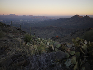
Skip the Thumb
by Crzy4AZ

 
Most people who hike Tom's Thumb trail from the North side are planning to visit its namesake "the Thumb". If you're looking for a different view then this is the hike for you. I enjoy Tom's Thumb north for its steep climb and good workout combined with a beautiful granite boulder field and incredible views along the ridge in all directions.


Follow the signs from the trailhead parking lot for Tom's Thumb trail about 1.6 miles to the junction with East End Trail. Stay on Tom's Thumb for another 0.5 miles to the sign for The Lookout trail. Go left (south) 0.5 miles to the dead end Lookout and look down and all around you. Windgate Pass is below and Thompson Peak not too far away. Behind you is the classic Thumb and East End Peak.
remove free decal offer
Return the way you came - or if you just can't resist stopping by the Thumb - then watch for a sign that says "Rock Climbing Access Route: Tom's Thumb/Gardener's Wall" about 0.1 miles from the junction with The Lookout. Taking that out/back section to the base of the Thumb adds 0.8 miles to your roundtrip total.

The trailhead has equestrian parking, two regular parking lots, info plaques, maps, and non-flushing bathrooms but NO WATER!

2014-03-13 Crzy4AZ


    Check out the Official Route and Triplogs.
    Leave No Trace and +Add a Triplog after your hike to support this local community.
    WARNING! Hiking and outdoor related sports can be dangerous. Be responsible and prepare for the trip. Study the area you are entering and plan accordingly. Dress for the current and unexpected weather changes. Take plenty of water. Never go alone. Make an itinerary with your plan(s), route(s), destination(s) and expected return time. Give your itinerary to trusted family and/or friends.

     Permit $$
    None


     Directions
    or
     Road
    Paved - Car Okay

    To Tom's Thumb Trailhead
    1) 101 (Pima Freeway) to Frank Lloyd Wright
    2) East on Frank Lloyd Right to N Thompson Peak Parkway
    3) North on Thompson Peak Parkway to McDowell Sonoran Preserve Gateway Trailhead to drop off first vehicle
    4) Then North on Thompson Peak Parkway to Pima Rd
    5) North on Pima Rd to Happy Valley Rd
    6) East on Happy Valley Rd until it turns north and changes to 116th st.
    7) East on Ranch Gate Rd to 128th St
    8) South on 128th to Park Entrance

    From Exit 36 of AZ-101 Loop North, head northeast on North Pima Rd 4.7 miles to East Happy Valley Road. Turn right onto East Happy Valley Road and drive 4.3 miles to Ranch Gate Road. Turn right onto Ranch Gate Road and travel 1.3 miles and then turn right onto North 128th Street. After 1.0 mile on North 128th Street, you'll be at the trailhead gate. No water at the trailhead! Bathrooms are non-flush.

    Warning
    If you just pop in the coordinates of the trailhead, it's very possible that your GPS unit will tell you to wrong turn from Happy Valley Road onto Alameda Road at ( 33.706667, -111.832396 ). Don't do it! Those GPS units don't know that there's a locked gate at (33.694441, -111.813335).

    From PHX (I-10 & AZ-51) 34.8 mi, 55 mins
    From TUC (Jct 1-10 & Grant) 135 mi, 2 hours 24 mins
    From FLG (Jct I-17 & I-40) 149 mi, 2 hours 37 mins
    page created by Crzy4AZ on Mar 13 2014 1:28 pm
     90+° 8am - 6pm kills
    helpcorrectionissue

    end of page marker