 Route Editor

| Guide | ♦ | 5 Triplogs | 0 Topics |
details | drive | no permit | forecast | 🔥 route |
stats |
photos | triplogs | topics | location |
| 63 | 5 | 0 |
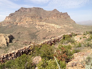
Another brick in the wall by kingsnake  Overview OverviewThis hike offers great views and ancient walls, with easy elevation gain and no threat of blood loss. Hike After parking east of the shooting range, walk west on FR 4 / Telegraph Rd. At 0.5 miles, you will cross a creek that flows south to north, towards Arnett Canyon, that is likely flowing even in dry weather. Flow is light, so it is easy to dry cross. Honestly, the up & downs along FR 4 for the first mile or so are the hardest part of the hike. You will see a large, stand-alone hill, that is almost white, with sheer walls of 50-150 feet. That is Hill 3012.
At 2.6 miles, get on a goat trail that cuts across a bend in Telegraph Canyon wash. Follow the barbwire fence, passing through the iron pole gate to Rock Tank. I'd be shocked if it was not full, as it has had plenty of water the times I have been out there. Follow the south shore of the tank, passing through the barbwire fence a second time at the tank's east end. At 3.2 miles, cross to the north side of Rock Tank's feeder creek, proceeding southeast on a very obvious foot trail along the exposed rock. The foot trail soon turns northeast toward Filaria Spring, whose vicinity you will reach at 3.6 miles. (I did not lay eyes on it.) Still on the foot trail, climb the final 150 ft. to the saddle. The foot trail continues east to the trailhead for the Wood Canyon Rim hike. (That loop routes south up a 300 ft. slope towards Hill 3419.) At 3.7 miles, turn north up a matching 300 ft. slope. As everywhere else on this hike, and the hills and slopes surrounding Picketpost Mountain, brush is not a factor: Here, mostly grass, some prickly pear and hedgehog, forests of ocotillo, and very few cat claw. As easy as cross-country travel gets in Arizona. Turn west at the top of the mesa. At 4.2 miles you will reach the Hill 3464 high point. Greats views of Telegraph Canyon. Follow the mesa rim north, towards Picketpost Mountain, then northeast. At 5.2 miles you will reach the first wall. It is 300 feet long, and up to five feet tall. Of the three wall segments we found, it is by far the largest. We did not find any ruins, pottery, or other signs of ancient life, but that does not mean you won't. It certainly seems like the walls are ancient because I can't image a rancher going to the effort of doing something like that when a barbwire fence is so much less labor-intensive to build. Plus, like SpiderLegs pointed out, the wall has slots that provide cover and great fields of fire. A few hundred yards on, you will run into wall segments two and three. At 5.4 miles, just past wall segment three, clamber over two six-foot boulders, to begin your descent to FR 4 / Telegraph Canyon Rd. It is steep, but again basically grab & stab free. You will hit the road at 5.6 miles, then turn east, returning to the trailhead. At 6.8 miles it is Guinness Time! Gate Policy: If a gate is closed upon arrival, leave it closed after you go through. If it is open, leave it open. Leaving a closed gate open may put cattle in danger. Closing an open gate may cut them off from water. Please be respectful, leave gates as found. The exception is signage on the gate directing you otherwise. Check out the Official Route and Triplogs. Leave No Trace and +Add a Triplog after your hike to support this local community. One-Way Notice This hike is listed as One-Way. When hiking several trails on a single "hike", log it with a generic name that describes the hike. Then link the trails traveled, check out the example. | |||||||||||||||||||||||||||||||||||||||||||||||||||||||||||||||||||||||||||||||||||||||||||||||||


