username
X
password
register
for free!
help


Austin Peak, AZ

Guide 1 Triplog  1 Topic
  4 of 5  
Fav
Wish
0
details
drive
permit
forecast
route  
stats
photos
triplog
topic
location
15 1 1
Statistics
tap row or icons for details
Difficulty 2.5 of 5
Distance Round Trip 1.55 miles
Trailhead Elevation 4,702 feet
Elevation Gain 965 feet
Accumulated Gain 986 feet
Kokopelli Seeds 6.48
 Interest Off-Trail Hiking & Peak
feature photo
Photos Viewed All MineFollowing
15  2014-03-16 chumley
Author
author avatar Guides 16,843
Routes 17,472
Photos 24
Trips 1 map ( 6 miles )
Age 28 Male Gender
Location HAZ, TrailDEX
Associated Areas
list map done
Northwest Region
Historical Weather
Trailhead Forecast
Radar Map
Expand Map
Preferred Oct, May, Apr, Nov
Sun  6:09am - 6:57pm
Official Route
 
0 Alternative


remove free decal offer

  
Guide Needed
Publish Full Detail Guide


Use +Add above to share photos and triplogs
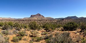
A prominent peak in the Aquarius Mountains, it's not even the highest peak within 2 miles, but it is the most impressive looking. Views from up top are 360 degrees of awesome.


    Check out the Official Route and Triplog.
    Leave No Trace and +Add a Triplog after your hike to support this local community.
    WARNING! Hiking and outdoor related sports can be dangerous. Be responsible and prepare for the trip. Study the area you are entering and plan accordingly. Dress for the current and unexpected weather changes. Take plenty of water. Never go alone. Make an itinerary with your plan(s), route(s), destination(s) and expected return time. Give your itinerary to trusted family and/or friends.

     Permit $$
    AZ State Recreational Land Permits
    For hiking, driving & sightseeing purposes, you seek a recreational permit.
    Under "Recreational Land Use" in the link above.
    2022 - $15.00 individual
    2022 - $20.00 family limited to two adults and children under the age of 18
    Plus $1 processing fee
    The permitting process is quick, you will be emailed your permit instantly.

    Land Parcel Map


     Directions
    or
     Road
    High Clearance possible when dry

    To hike
    From US93, turn right on Hackberry Road, 4.5 miles south of I-40 and 28 miles north of Wikieup. Travel .75 miles and turn right onto Knight Creek Rd (marked). At 6.75 miles stay right at the fork (Knight Creek Rd. goes left) and continue as the road narrows and gets rougher. At 11 miles you pass through Cedar Basin. Continue on to to the 13.75 mile mark and turn left on a road heading for the saddle on the east side of the mountain. Drive half a mile to the saddle and start from there.
    page created by chumley on Mar 16 2014 10:31 pm
     90+° 8am - 6pm kills
    helpcorrectionissue

    end of page marker