|
tap row or icons for details
|
| Difficulty |
|
1 of 5 |
| Route Finding |
|
2 of 5 |
| Distance Loop |
|
8.3 miles |
| Trailhead Elevation |
|
1,517 feet |
| Elevation Gain |
|
100 feet |
| Avg Time Round Trip |
|
2 hours |
| Interest Ruins & Historic | | Backpack No | |
| | |
|
|
| |
|
|
Historical Weather |
| Trailhead Forecast | | |
|
 |
|
|
| Preferred Jan, Feb, Dec, Mar |
| |
|
|
| | |
| |
Named Locations Coordinate Links
| |
|
| help future road bikers |
| post a gps route now |
| | |
| |
|
|
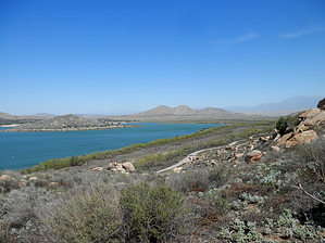
 This loop is supposed to be 8.3 miles around the but it was closed off on the dam and did not appear to be opening up anytime soon. The bike loop is nice. Hardly anybody was there, but I assumed that it gets crowded on the weekends. There are petrogylphs, rock climbing, and mountain biking on the the south end. The north end of the lake is more for family activities, like boating, swimming, and horseback riding. There's a museum, but it was closed when I was there. I think there's an entrance fee ( link in fees/permits section ). There are signs posted everywhere, but I could not find a place to pay. Perhaps it is free during the week. The trail is mostly paved and marked well, but it can be difficult to follow when you get into the parking and camping areas on the north end. You can bike off the main path, but the sandy soil made it tough to ride in some areas. Squirrels and lizards are frequently encountered along the path. There are some birding opportunities there, but for a big lake, it did not have as many birds as I would have thought. You can also rent bikes there. |
 Route Editor