Route Editor

| Guide | ♦ | 46 Triplogs | 0 Topics |
details | drive | permit | forecast | route |
stats |
photos | triplogs | topics | location |
| 452 | 46 | 0 |
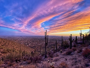
The other Usery Mountain by adilling  Prologue PrologueWhen you hear Usery Mountain, most people naturally think about Usery Mountain Regional Park and the iconic mountain with the big yellow tuff streak across the top. That is actually Pass Mountain. This hike goes up to the three peaks of Usery Mountain, which is on the opposite side of Usery Pass Road. There are three distinct peaks at the top - 2972, 2959, and 2933. This hike starts at the Lone Mountain Trailhead, which is 1.7 miles north of the entrance to Usery Mountain Regional Park. Parking is free and does not require a Tonto Pass.
From the trailhead, cross over Usery Pass Road and access the wash. The first 0.6 miles of the hike is straight up the wash area. There are optional paths/bushwhacks on either side if you don't care for sandy wash hiking. It goes pretty fast either way. Once you reach a split in the wash at the 0.6-mile point, you climb up the little plateau to access the main trail going up. It's a popular mountain bike path called "Old Goat". At the 1.45 mile point, you will need to access the final portion of the trail going up. There is a faint trail going off to the right just past the Old Goat/High Ridge Trail junction. The path is not as clear as the mountain bike trail, and it is much steeper. It's only 0.25 miles from the Old Goat trail to the saddle. There are a few steeper sections with a little loose ground to traverse. Take care going up and down in these sections. Once you access the saddle, Peak 2972 and the rocky Peak 2959 are to the left, and Peak 2933 is to the right. All three have easy-to-follow trails between them. There are great views looking west from the top in all directions; the Phoenix valley and surrounding mountains to the west, Red Mountain and the McDowells to the north, Four Peaks, the Lower Salt River Valley, Pass Mountain, the Goldfields, and the Superstitions to the east. Synopsis If you are looking for a similar hike to the Wind Cave/Pass Mountain or the twin brother across the street, Lone Mountain/EJ Peak, this is a great alternative. A path less traveled with not many hikers clogging the trails. Excellent views, a nice workout, and not crowded. Check out the Official Route and Triplogs. Leave No Trace and +Add a Triplog after your hike to support this local community. | |||||||||||||||||||||||||||||||||||||||||||||||||||||||||||||||||||||||||||||||||||||||||||||||||||||||||||||||||||||||||||||||||||||||||||||||||||||||||||||||||||||||||||||||||||||||||||