Route Editor

| Guide | ♦ | 11 Triplogs | 0 Topics |
details | drive | no permit | forecast | 🔥 route |
stats |
photos | triplogs | topics | location |
| 105 | 11 | 0 |
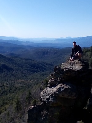
Forever real, let me take you up! by SonoranBound   Park just outside the Forest Service gate at the end of Ernies Rd in Strawberry AZ. Walkthrough the gate closing it behind you. Follow the small road for several yards looking to the left for a trail heading up peak 6631. Follow This "trail" as long as you can as it quickly disappears near a fence/property line. Follow this fence up switchbacking where necessary as the way up becomes very steep. As the grade continues to become steeper the fence ends. At this point look for the path of least resistance to gain the ridge. This is the hardest part of the hike and where you gain the majority of your elevation. Park just outside the Forest Service gate at the end of Ernies Rd in Strawberry AZ. Walkthrough the gate closing it behind you. Follow the small road for several yards looking to the left for a trail heading up peak 6631. Follow This "trail" as long as you can as it quickly disappears near a fence/property line. Follow this fence up switchbacking where necessary as the way up becomes very steep. As the grade continues to become steeper the fence ends. At this point look for the path of least resistance to gain the ridge. This is the hardest part of the hike and where you gain the majority of your elevation.After gaining this first ridge, it is a good idea to mark the spot with a cairn to mark your way down. Once placing a Cairn continue in a south-eastern direction looking for the high ground and top of peak 6631. This section is mostly flat, but it is not hard to see where the high point of this peak is. Once reaching the top directly to your left is the first taste of the amazing views on this hike. A sheer drop and great views of the Mogollon Rim greet you on top of peak 6631. After taking a moment here, I would recommend laying another cairn, continue south towards Strawberry Mountain/peak 6813.
Gate Policy: If a gate is closed upon arrival, leave it closed after you go through. If it is open, leave it open. Leaving a closed gate open may put cattle in danger. Closing an open gate may cut them off from water. Please be respectful, leave gates as found. The exception is signage on the gate directing you otherwise. Check out the Official Route and Triplogs. Leave No Trace and +Add a Triplog after your hike to support this local community. | ||||||||||||||||||||||||||||||||||||||||||||||||||||||||||||||||||||||||||||||||||||||||||||||||||||||||||||||||||||||||||||||||||||||||||||||||||||||||||||||||||||||||||||||||||||||||||||||||