From the Frazier Trailhead, the trail meanders over low ridges and through drainages until it drops into Cottonwood Canyon. Then it goes up the canyon and junctions with FR 341 which serves as the trail. Turn left onto FR 341 and travel south for approximately 1.5 miles. The trail takes off from the road to the south and continues to follow Cottonwood Canyon. After approximately 3 miles, the trail reaches the southern terminus at FR 83.
When hiking several trails on a single "hike", log it with a generic name that describes the hike. Then link the trails traveled, check out the example.
WARNING! Hiking and outdoor related sports can be dangerous. Be responsible and prepare for the trip. Study the area you are entering and plan accordingly. Dress for the current and unexpected weather changes. Take plenty of water. Never go alone. Make an itinerary with your plan(s), route(s), destination(s) and expected return time. Give your itinerary to trusted family and/or friends.
Permit $$
None
Directions
Road
Paved - Car Okay
To hike From the Roosevelt Dam, drive 1.5 miles east on SR 188 to the Lakeview Trailer park (across the road is the ranger station); turn onto the trailer park entrance road. Then make a quick right turn to the Cemetery TH.
North End: Frazier TH: From Roosevelt Dam, take State Highway 188 for 2 miles southeast to Forest Road (FR) 173. This road is on the south side of the highway and just west of a power substation. South End: Forest Road 83: >From Roosevelt Dam, take State Highway 188 southeast approximately 6 miles. Turn right (southwest) onto FR 83 and drive approximately 3.3 miles to the trail connection. The trail begins on the north side of the road. A 4-wheel drive vehicle with high clearance is necessary for the last 2 miles to the trailhead. 4-wheel-drive recommended on FR 83 and FR 341.
 Route Editor


 From the Frazier Trailhead, the trail meanders over low ridges and through drainages until it drops into Cottonwood Canyon. Then it goes up the canyon and junctions with FR 341 which serves as the trail. Turn left onto FR 341 and travel south for approximately 1.5 miles. The trail takes off from the road to the south and continues to follow Cottonwood Canyon. After approximately 3 miles, the trail reaches the southern terminus at FR 83.
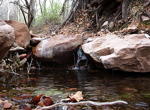


