username
X
password
register
for free!
help
  
   🔥

Senator Highway - Crown King to Prescott, AZ

Guide 9 Triplogs  0 Topics
  3 of 5  
Fav
Wish
0
details
drive
permit
forecast
🔥
route  
stats
photos
triplogs
topics
location
89 9 0
HAZ reminds you to respect the ruins. Please read the Archaeological Resources Protection Act of 1979 & Ruins Etiquette
Statistics
tap row or icons for details
Distance One Way 39 miles
Trailhead Elevation 5,780 feet
 Interest Ruins, Historic, Seasonal Waterfall & Seasonal Creek
feature photo
Photos Viewed All MineFollowing
Inaugural Calculation on Button Tap!
12  2024-11-22
Horse Mountain Trail #212
DixieFlyer
7  2024-11-08
Juniper Ridge - Castle Creek Wilderness HP
DixieFlyer
19  2021-12-28
Pleasant to Prescott 4x4
Stoic
9  2015-07-18
Crooks Canyon - Ash Creek Canyon Loop
The_Eagle
23  2014-09-03 The_Eagle
30  2014-03-29
Road to Crown King
Randal_Schulhaus
36  2008-08-27
Crown King - After the Fire 2008
rwstorm
12  1979-09-06
Bradshaw Mountains 1979
rwstorm
Author
author avatar Guides 16,843
Routes 17,472
Photos 24
Trips 1 map ( 6 miles )
Age 28 Male Gender
Location HAZ, TrailDEX
Historical Weather
Trailhead Forecast
Radar Map
Expand Map
Preferred Apr, Oct, May, Mar
Sun  6:05am - 6:50pm
Official Route
 
4 Alternative
 
Historic Fire Perimetersacres
🔥 2022-05-02 Crooks39.4 mi*
🔥 2020 Horse Fire21.7 mi*
🔥 2019 Cellar Fire29.8 mi*
🔥 2018 Stubbs Fire34.7 mi**
🔥 2017 Goodwin Fire49.0 mi*
🔥 2012 Gladiator Fire37.9 mi*
🔥 2008 Lane 2 Fire27.4 mi*
🔥 View (All) - over Official Route 🔥
*perimeter length in miles
**possible voids inflate figure


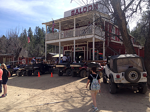
The Old Senator Highway was originally constructed in 1866 as a toll road between Prescott and the Old Senator Mine near present day Crown King. Today this is a 4x4 trail.


A map of the route can be constructed using Google Maps by entering directions for Crown King AZ to Bradshaw City AZ to Groom Creek AZ to Prescott AZ. The result is 39.0 miles, 2 hours 27 minutes drive time.
remove free decal offer


    Check out the Official Route and Triplogs.
    Leave No Trace and +Add a Triplog after your 4x4 trip to support this local community.
    WARNING! Hiking and outdoor related sports can be dangerous. Be responsible and prepare for the trip. Study the area you are entering and plan accordingly. Dress for the current and unexpected weather changes. Take plenty of water. Never go alone. Make an itinerary with your plan(s), route(s), destination(s) and expected return time. Give your itinerary to trusted family and/or friends.

     Permit $$
    no fees or permits reported

    if incorrect tell us about it

    Prescott Forest
    Prescott National Forest Pass

    Only trailheads with six "amenities" have fees. Amenities are picnic tables, trash, toilet, parking, interpretive signing and security.


     Directions
    or
     Road
    Strictly 4x4

    To 4x4 trip
    page created by Randal_Schulhauser on Mar 30 2014 10:09 pm
     90+° 8am - 6pm kills
    helpcorrectionissue

    end of page marker