 Route Editor

| Guide | ♦ | 22 Triplogs | 3 Topics |
details | drive | permit | forecast | map |
stats |
photos | triplogs | topics | location |
| 243 | 22 | 3 |
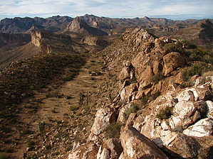
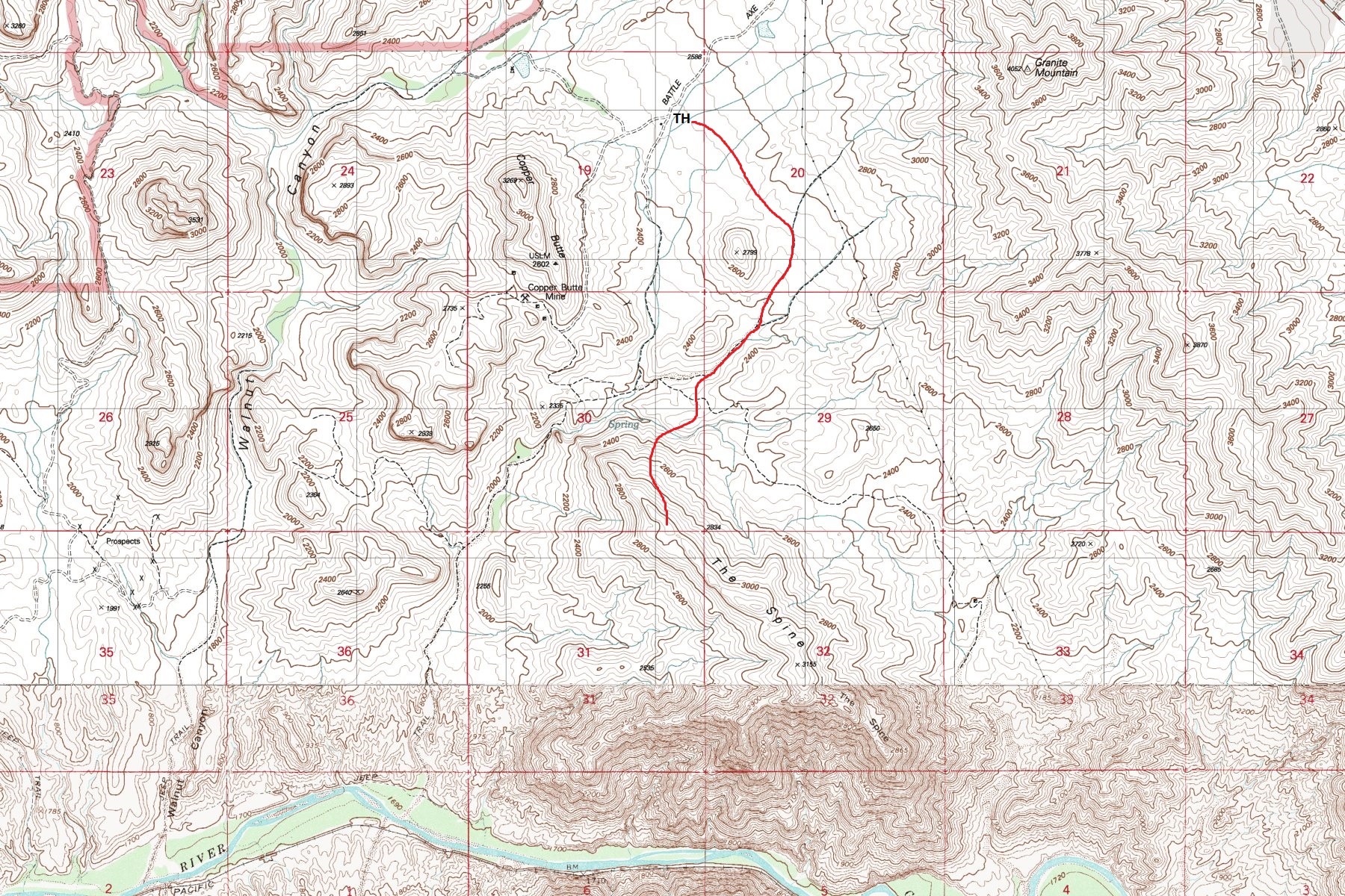
Hang on... It's going to be a ROUGH ride!! by ssk44  Warning WarningAs of 2015, the original initial route as noted in this hike description has been blocked near the Copper Butte Mine claim. Do not hike through the Copper Butte Mine. See attached map for off-trail route option bypassing the Copper Butte Mine claim. Overview "The Spine" is a steep and rugged narrow ridgeline that towers above the surrounding area, heading out to an amazing overlook of the Gila River valley. Its located within a small segment of remote State Trust land and is surrounded by BLM land. State Trust and BLM land are checkerboarded throughout the area and you must know where you are due to required recreational access permits on State Trust land. Seeing this ominous location on a topo map truly inspires curiosity. With the adventurous spirit that I have, it was mandatory to explore the location.
"The Spine" is a rugged cross-country route. There is no trail. The hike as posted begins at a large parking area next to a corral off of Battle Axe Road. You will initially be hiking on a jeep trail that ends up in a sand wash. Those with 4x4 vehicles could continue driving down the jeep trail and park near the base of the mountain. From the parking area, start walking southwest on the jeep trail next to the corral. There is a cattle guard at the start of the road. Follow the sand wash to the second side canyon near the mountain ("Mark 003", Lat. 33 degrees/8'/29.61"/N & Long. 111 degrees/3'/23.81"/W). This canyon has a spring along it and usually has water running in the bottom. Continue up this drainage until you reach a small fork heading off to the right ("Mark 004", Lat. 33 degrees/8'/23.97"/N & Long. 111 degrees/3'/5.76"/W). Continue up this small side canyon to a saddle ("Mark 005", Lat. 33 degrees/8'/21.85"/N & Long. 111 degrees/2'/59.81"/W). From the saddle, you will begin the climb to the top. Don't panic, this climb is easier than it looks with mostly solid footing all the way up. There was minimal loose and dangerous rubble rock. From here you will be following a fairly defined wide ridge that heads up to the halfway point ("Mark 006", Lat. 33 degrees/8'/13.20"/N & Long. 111 degrees/3'/8.55"/W). At the halfway point the ridge ends and you will now be climbing straight up to the top ("Mark 007", Lat. 33 degrees/8'/8.01"/N & Long. 111 degrees/3'/14.14"/W). This last segment is steep and primarily consists of medium size boulders. The footing is good and solid. Take your time, pick your line, breathe out every once in a while and you will be on top in no time at all. Once you're on top the route is fairly self-explanatory. The first part of "The Spine" is the most precarious with nothing more than a narrow line of large boulders and steep slopes on both sides. The boulders felt very solid and were perfectly placed for hopping from one to another. On the right, there is an amazing hidden shelf about eighty feet +/- below the ridgeline. After you get through this stretch, things get easier. About halfway along the ridge, you will come up to a steep cliff drop that extends out to the north. Backtrack a little bit and you will see a line on your right (south) heading down and around the obstacle. You're almost there. The last stretch is pleasantly smooth and open. When you finally reach the end above the Gila River, there will be a fork heading to the right and left. Once you have come this far, you will have to explore both of these forks. They are very alluring and give better views of the river below. The main fork continuing to the southeast has many up-and-down sections and had a considerable drop in elevation of about 280'. At the most prominent end of each fork were existing cairns from the brave few that were there before me. See maps for locations of GPS waypoints described in the text. Summary Hiking "The Spine" can only be described as epic. This hike delivers from start to finish. This hike is no pleasure cruise and should be treated accordingly. It's a rugged route that demands respect. Although somewhat difficult and precarious in places, it is a very manageable route with minimal bushwhacking. The feeling that comes from the ominous remote isolation, the steep rugged down slopes, the 360-degree views, the high gain in elevation above the valleys and canyons below, and the cold wind in your face can not be properly described. Trying to capture its grandeur in photos is almost impossible. You truly have to see it in person. Count on having it all to yourself if you go. Check out the Triplogs. Note This is a moderately difficult hike. Leave No Trace and +Add a Triplog after your hike to support this local community. | |||||||||||||||||||||||||||||||||||||||||||||||||||||||||||||||||||||||||||||||||||


